


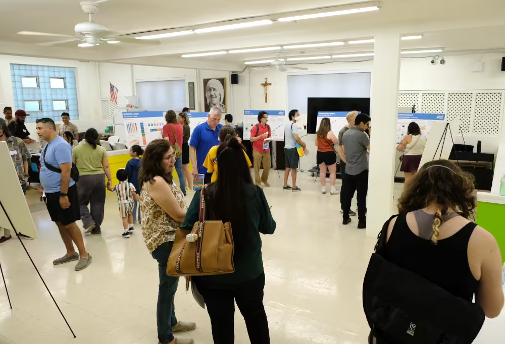
West 35th Street in Chicago’s McKinley Park neighborhood may be the next protected route for bikers, according to planning documents, officials’ statements and the lack of biking infrastructure contained in Moving Archer Forward, a Chicago Department of Planning and Development (DPD) study on improving South Archer Avenue.


The department hosted its open house on July 8, 2026, to present the final draft of Moving Archer Forward, which, if accepted by the Chicago Plan Commission, would provide “something strong to point to” when making development decisions, said DPD City Planner Haley Cannon.

The study area includes South Archer Avenue and the properties along it from South Halsted Street to South Cicero Avenue, passing through multiple city wards and neighborhoods, including McKinley Park.
See the final results of our news poll: Bike Lanes on West 35th Street
Read the related article: "No Plans to Remove Parking for Bike Lanes, Says Alderwoman"
Protected Bike Lanes
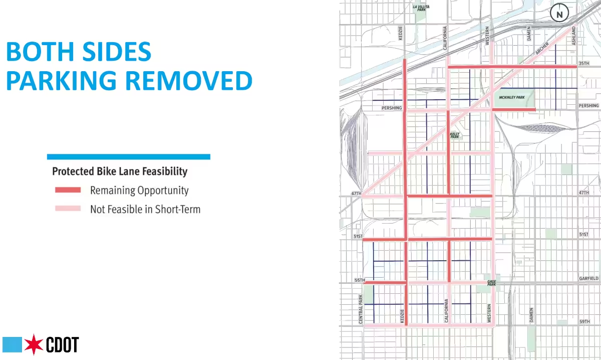 A presentation slide from the Southwest Side Neighborhood Bike Network task force shows proposed locations for protected bike lanes with parking removal.A 30-day comment period on the study ends on August 6, with the plan commission set to formally consider adoption on August 20, 2026, Cannon said.
Although it did highlight areas where biking was difficult, the study did not mention or advocate for protected bike lanes to be built on South Archer Avenue, including its reach through the McKinley Park neighborhood from South Western Avenue to the Archer Avenue bridge over Bubbly Creek.
Routine Maintenance Only
This stretch is part of a designated state road and truck route controlled by the Illinois Department of Transportation (IDOT), where the Chicago Department of Transportation (CDOT) has no jurisdiction.

“CDOT manages sidewalks and street lighting along the entire length of the corridor but is not necessarily authorized to do more than routine maintenance,” the study said.
Construction Unlikely
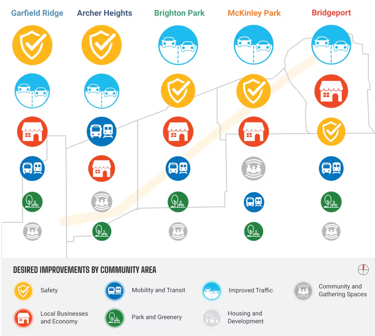 Top desired community improvements include better traffic and safety, as shown here in a graphic from the Moving Archer Forward plan.“The IDOT Multi-Year Plan does not include any identified projects on Archer within the study area,” the Moving Archer Forward study said. “In the next five years, there is unlikely to be additional construction along the corridor.”
Cannon said she could not speak to the issue of bike lane infrastructure on South Archer Avenue or elsewhere in the area.
Brighton Park Lanes
A CDOT Complete Streets project has added protected bike lanes to South Archer Avenue in the Brighton Park neighborhood alongside traffic-calming measures and removal of street parking and turn lanes.
These protected bike lanes end at South Western Avenue at the edge of the McKinley Park neighborhood without connecting to other designated bike routes.

Drops Off Sharply
“Data shows that only a small number of people cycle on Archer,” the Moving Archer Forward study said. “Those that do are a dedicated constituency.”

“[Bicycling] usage drops off sharply to the west of Western Avenue,” the study said.
Complete 35th Street
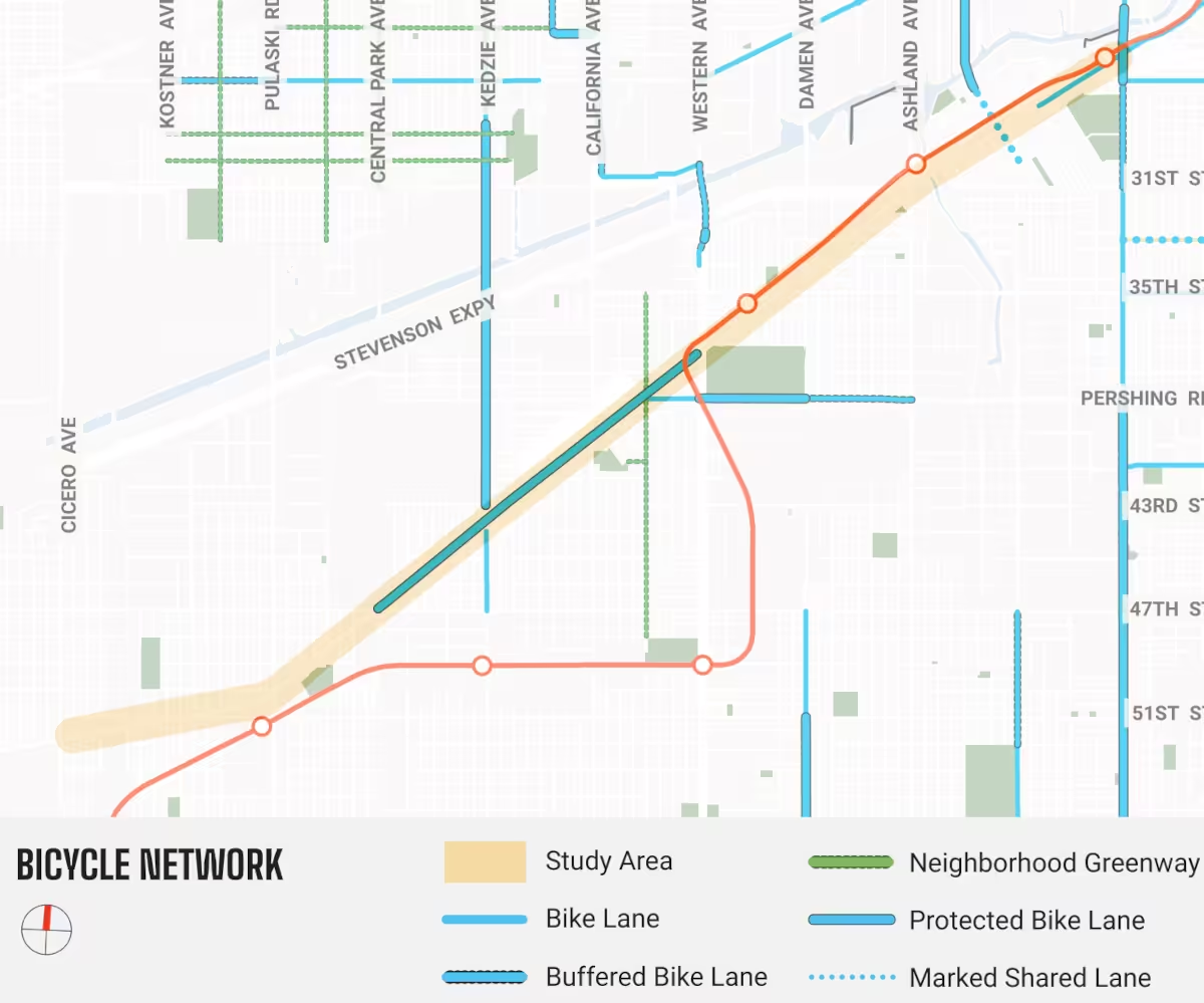 A map from the Moving Archer Forward plan shows the gaps in bike routes in the McKinley Park neighborhood.Creating a connected bike network is a priority for the City of Chicago, as stated in its Chicago Cycling Strategy. It’s also supported by local transit advocacy non-profits like the Active Transportation Alliance, Streetsblog Chicago and Bike Grid Now.
Nicole Lee, 11th Ward alderwoman, announced in her June 14, 2026, newsletter consideration of Complete Streets renovation for West 35th Street stretching from South Halsted Avenue west to South Ashland Avenue.
CDOT Next Phase
“I’ll be meeting with CDOT to discuss the next phase,” she said, adding that community engagement will take place during planning “and before anything is finalized.”
This stretch of West 35th Street does not currently have Complete Streets features, which can include protected bike lanes.
Bike Task Force
No bikeway currently traverses the McKinley Park neighborhood, although protected and buffered bike lanes are available on parts of West Pershing Road and South Western Avenue.
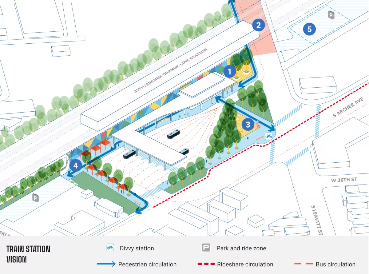 The Moving Archer Forward plan proposed improvements to the 35th/Archer Orange Line El station, including 1) murals, 2) a painted crosswalk, 3) a plaza and seating and 4) a shaded area.Moving Archer Forward did highlight CDOT’s Southwest Side Neighborhood Bike Network Task Force, which identified West 35th Street between South Ashland Avenue and South California Avenue as a “primary project” that “will help form the backbone of the network.”
Parking Removal
The task force called for removing West 35th Street street parking and replacing it with protected bike lanes at its last meeting in November 2023, which included nine individuals representing 11th and 12th wards, and representatives from community groups, including the McKinley Park Development Council.
Published notes from the meeting stated the “limited opportunity for protected bike lanes without tradeoffs with on-street parking.”
12th Ward
Although earlier task force discussions had looked at the existing bike lanes on West Pershing Road as a primary connection, “taskforce members … felt the bike network should focus on protected bike lanes on streets such as Archer and 35th,“ meeting notes said.
12th Ward Chief of Staff Bill Drew participated in the task force meeting and approved of the plan for West 35th Street, meeting notes stated. “He felt overall the plan creates a good network,” the notes said.
Older and Wealthier
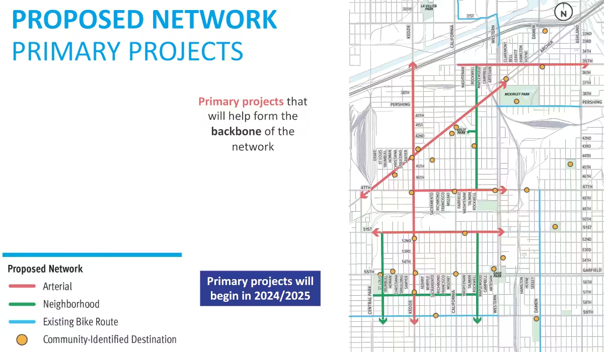 A slide from the Southwest Side Neighborhood Bike Network task force shows planned primary and secondary bike routes through neighborhoods.Moving Archer Forward itself contains only a few specific recommendations for bike infrastructure, such as recommending bike (and pedestrian) improvements over the Bubbly Creek bridge.
However, it does feature a plethora of information on McKinley Park’s and other neighborhoods’ economic and social conditions, demographics, market environment and residential incomes, with McKinley Park becoming older and wealthier more quickly than any other community in the study.
Traffic and Safety
Moving Archer Forward identifies its top three priorities as safety, creating destinations and applying development and civic benefits equally among all communities. Its recommendations stem from community feedback starting in February 2025 that included pop-ups, advisory groups and public presentations.
In McKinley Park, as in most neighborhoods of the study, the No. 1 identified community desire was for improvements to vehicular traffic. In McKinley Park and Brighton Park, the next most-desired improvements were for safety, then support for businesses.
El Stations Redesign
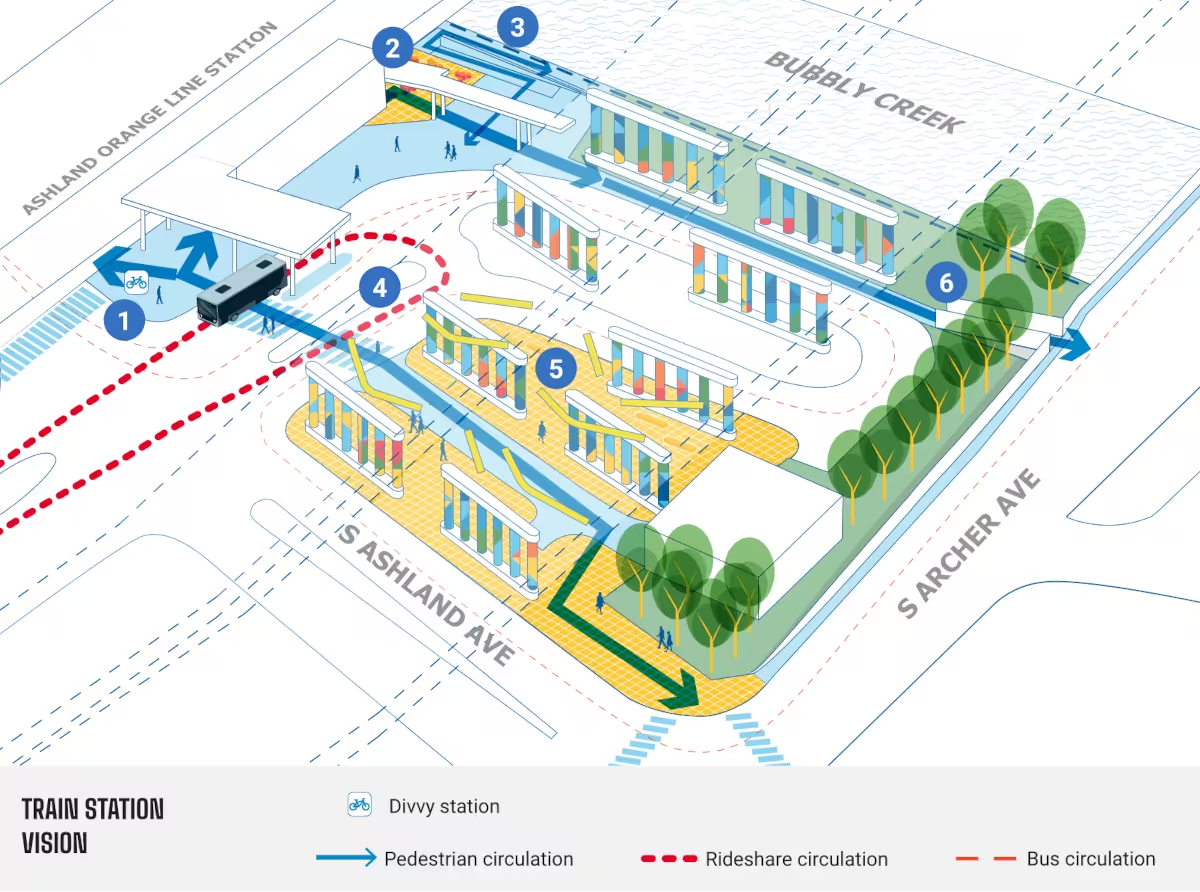 The Moving Archer Forward plan proposes 1) a Divvy station, 2) a riverwalk plaza, 3) a ramp to a river trail, 4) drop-off reconfiguration, 5) a pedestrian plaza and 6) an accessible ramp to the Archer bridge at the Ashland El Station.Moving Archer Forward includes specific recommendations for zoning on the corridor, as well as lists of action items and who should conduct them, in time frames ranging from two to five years, five to 10-plus years and ongoing.
Some of the plan’s most detailed recommendations looked at improvements for Orange Line El stations and the properties adjacent to them, including the McKinley Park neighborhood’s 35th/Archer El station and Ashland El station.
Reduced Parking Requirements
As Moving Archer Forward notes, most of the McKinley Park neighborhood falls within a Transit-Served Location area: within ½ mile of an El stop and within ¼ mile of major bus corridors.
“This eases zoning regulations, providing incentives for developers and property owners such as reduced parking requirements to incentivize density,” the study said.
Bike Connectivity Gap
Equitable Transit-Oriented Development (ETOD) principles are City of Chicago policy and applied throughout Moving Archer Forward “to benefit from compact, mixed-use and pedestrian-oriented development near transit hubs,” the study said.
Moving Archer Forward’s Bicycle Network illustration displays the big gap in bike route connectivity across the McKinley Park neighborhood.
Secondary Routes
In presentation slides, CDOT’s task force also highlighted the need for secondary bike routes, including on West 37th Street and South Wood Street in the McKinley Park neighborhood.
No specific plans or proposals for protected bike lanes on West 35th Street have otherwise been published or shared by public officials or community groups.
Vocal Minority
Much of West 35th Street’s stretch through the McKinley Park neighborhood is split between the 11th Ward on its north side, and the 12th Ward on its south side. Recently, Lee and 12th Ward Alderwoman Julia Ramirez have collaborated on up-zoning properties in this span, as previously reported here in the McKinley Park News.
“We will keep organizing till it happens,” Bike Grid Now states on its website. “We certainly can’t let a vocal minority get in the way of a safer, more equitable, healthier and better city.”


Log In to comment on this item.
Subscribe
Report
My comments