


The Western Avenue/Western Boulevard Streetscape Plan, completed in May 2011, was created to provide the City of Chicago with a guide for future streetscape and right-of-way improvements along the corridor. The project area encompassed Western Avenue/Boulevard from 31st Street on the north, to 49th Street on the south. The overall focus of the plan is to identify streetscape recommendations that could be possible within the existing environment. The plan was designed as a framework for future improvements, to be supplemented with all available best management practices for streetscape conditions. The project evaluated both the aesthetic considerations and functional needs as a system, including drainage, circulation, maintenance of existing trees, and code and standard compliance. Plan goals include:
- Utilize the existing right-of-way in a manner that balances the needs of vehicular, bus, pedestrian, and bicycle circulation.
- Protect pedestrians from possible swift-moving vehicular traffic at crossing sites.
- Encourage walking, bicycling, and transit usage along the corridor by improving transfer point facilities between different modes of travel.
- Encourage the use of the parkway and its development for uses such as cafés, bench seating, bicycle parking, and bus stops.
- Provide complete streets and appropriate facilities for all users, including pedestrians, children, people with disabilities, and bicyclists.
This section of the neighborhood plan presents strategies that align with the goals presented in the Western Avenue/Boulevard Streetscape Plan. The recommended strategies focus on providing greater access, improving safety, and reducing congestion while improving the overall livability of residents through expanded open space areas.
Explore the feasibility of converting Western Avenue/Boulevard to a one-way couplet from 35th Street to Pershing Road
The conversion of Western Avenue and Western Boulevard from two- way operations to one-way couplets would provide benefits to pedestrians, bicyclists, and transit riders. Creating one-way couplets reduces many potential modal conflicts and provides opportunities to expand sidewalk width, add buffer space, and expand bicycle infrastructure. The motivation behind this idea stems from the Midway Plaisance, which is a boulevard style one-way couplet roadway located just south of the University of Chicago. The traffic-calming and increased safety benefits provided to pedestrians and bicyclists through converting Western Avenue/Boulevard to one-way couplets would also allow the green space between the roadways to experience greater activation and use. Additionally, proposed improvements should examine the integration of shared-used paths and curb bump-outs to create safer access to and from McKinley Park.
Studies concerning bus turnings, routing, bus stop locations, and traffic modeling congestion should consult CTA. CDOT should coordinate with IDOT and the Cook County Department of Transportation and Highways to examine this concept idea through an engineering study. This project could be funded through CMAP’s Congestion Mitigation and Air Quality Improvement (CMAQ) program.
Image 5.8 Examples of People Spots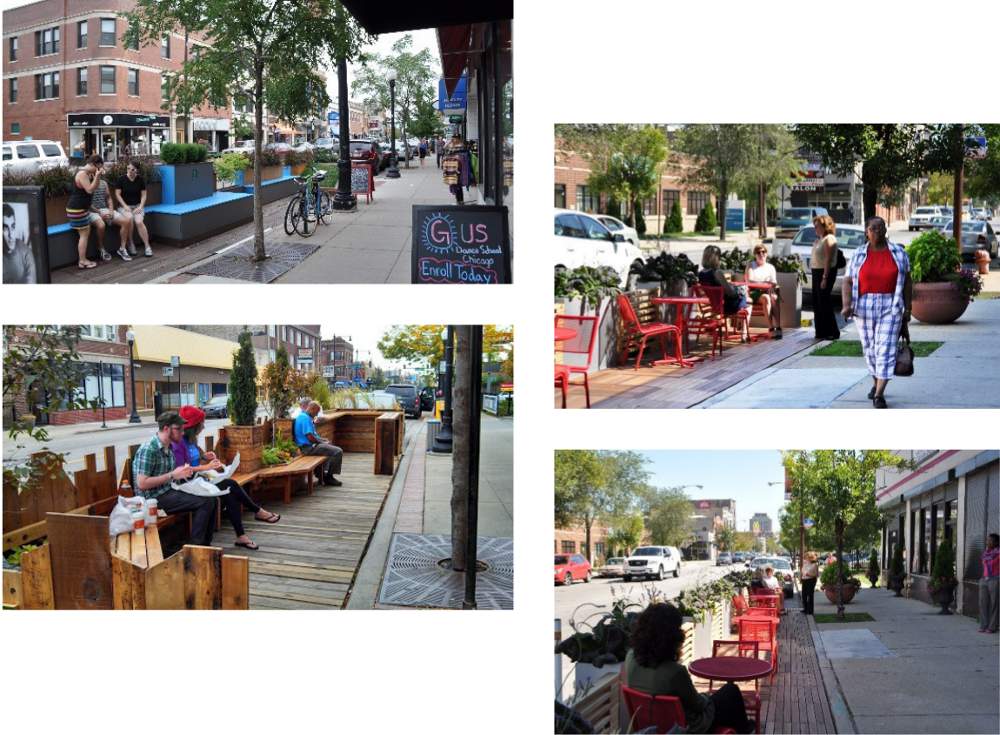
Concept ideas for further study
The illustrated streetscape concepts are only meant to show the possibilities of how each of these corridors could be repurposed to provide greater access, improve safety, and reduce congestion. A feasibility study would be an appropriate next step to ensure the recommendations being proposed are the best possible solutions.
Exhibit 5.4 Western Avenue & 33rd Street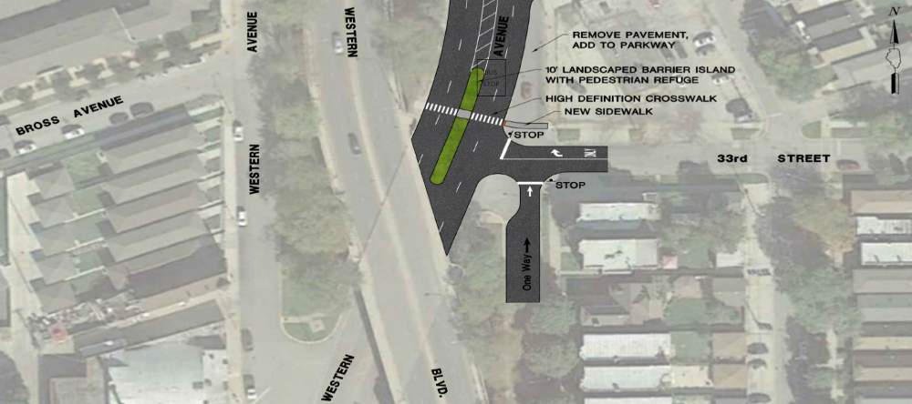
Western and 33rd: Western Avenue should maintain the current two-way operations north of 35th Street. Facilitating one-way operations north of the existing 35th Street intersection could have a negative impact on safety due to roadway geometrics and sightline restrictions caused by Western Boulevard traversing above Western Avenue.
At its intersection with 33rd Street, Western Avenue currently has a striped center median separating two lanes of traffic in each direction. CDOT should explore the addition of a landscaped barrier island that supports a pedestrian refuge where the previous striped center median is located to provide a safer experience crossing Western Avenue.
The curb line of the existing parcel located in the northeast quadrant of the Western Avenue and 33rd Street intersection could be extended westward and the recaptured area should be repurposed as parkway. This parkway would provide increased separation between traveling vehicles and pedestrians.
Exhibit 5.4 illustrates potential treatments that could be proposed with the curb line being extended westward. These include pushing the stop bar location for westbound 33rd Street vehicles further west. The current stop bar location has sightline issues due to the viaduct of Western Boulevard being located immediately south of the intersection. A sidewalk extending fully across Western could also be beneficial.
Additionally, a median extension at the southwest corner of the intersection will prevent vehicles traveling along the one-way northbound continuation of Western Boulevard from attempting to turn left and head back southbound on Western Avenue.
Currently, westbound traffic along 33rd Street is restricted from making left turns on Western Avenue through signage; however, vehicles probably still make this dangerous maneuver. Both the landscape barrier median and the curb bump-out physically prevent the left-turning maneuver and should increase safety at the intersection.
Exhibit 5.5 Western Avenue & 35th Street
Western and 35th: 35th Street marks the northern terminus of the proposed one-way couplet along Western Avenue/Boulevard. The south legs of both Western Avenue and Western Boulevard would have reduced pavement sections under the proposed one-way reconfiguration. This will allow crossing distance for pedestrians to be shortened in half by converting existing pavement to parkway.
Due to the conversion from two-way operations to one-way couplets, the north leg of the Western Boulevard and 35th Street intersection has the opportunity to provide a landscaped median with a pedestrian refuge.
There is currently a 12-foot shared-use path in disrepair that runs north-south along the boulevard median between Western Avenue and Western Boulevard. It is recommended that this path be repaved, as it would require no tree removal due to its existing location.
The sidewalks that border the boulevard median are recommended to be 10 feet in width and buffered roughly 5 feet from the roadway where possible. This change would create a more friendly and inviting pedestrian environment within the boulevard median and ideally lead to an activation of the green space.
Western and Archer: CTA Route No. 49, which travels on Western Avenue, would travel on the east roadway northbound and the west roadway southbound. This treatment recommends exploring the relocation of existing bus stops or shelters on the northbound side of the existing Western Avenue to the one-way northbound lane.
It should be noted that heavy freight traffic is currently allowed along Western Avenue and restricted along Western Boulevard. One downside of converting Western Avenue/Boulevard from two-way operations to one-way couplets would be the heavy freight traffic utilizing both roadways. Findings from CMAP’s Chicago Southwest Communities Truck Abatement Study should be considered during the exploration of this concept idea.
Exhibit 5.6 Western Avenue & Archer Avenue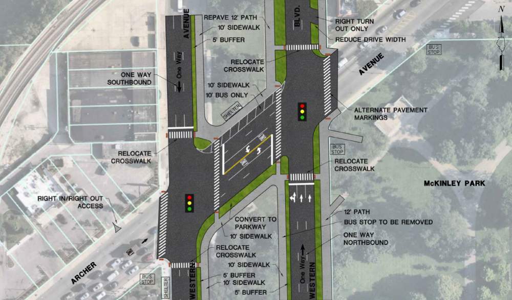
Western and Archer: CTA Route No. 49, which travels on Western Avenue, would travel on the east roadway northbound and the west roadway southbound. This treatment recommends exploring the relocation of existing bus stops or shelters on the northbound side of the existing Western Avenue to the one-way northbound lane.
It should be noted that heavy freight traffic is currently allowed along Western Avenue and restricted along Western Boulevard. One downside of converting Western Avenue/Boulevard from two-way operations to one-way couplets would be the heavy freight traffic utilizing both roadways. Findings from CMAP’s Chicago Southwest Communities Truck Abatement Study should be considered during the exploration of this concept idea.
Exhibit 5.7 Western Avenue & Pershing Road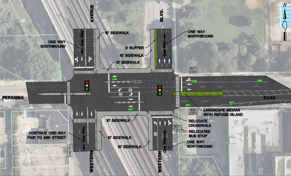
Western and Pershing: The Western Avenue/Boulevard and Pershing Road intersections experience the most crashes in the study area. The high number of crashes is likely the result of confusing roadway geometrics along with both the grade-separated freight and CTA railroad tracks running over the top of the intersection. As previously stated, converting Western Avenue/Boulevard to one-way couplets would reduce the potential for modal conflicts at both of these intersections. Pedestrians and transit riders would have reduced crossing distances at the intersections and bicyclists would be able to navigate with reduced points of conflict.
This concept recommends studying the continuation of the one-way conversion pair to 49th Street. Due to the conversion from two-way operations to one-way couplets, there is an opportunity to add a landscaped median with a pedestrian refuge to the east side of the Pershing Road and Western Boulevard intersection. See Exhibit 5.7.
As previously mentioned, heavy freight traffic is currently allowed along Western Avenue and restricted along Western Boulevard. A downside of converting Western Avenue/Boulevard from two-way operations to one-way couplets would be the heavy freight traffic utilizing both roadways.
The viaduct on Western Avenue/Boulevard and Pershing Road is particularly unsafe due in large part to its many railroad support columns (see Image 5.8). This viaduct creates a visual and physical barrier between McKinley Park and neighborhoods to the west and south. Currently, Norfolk Southern Corporation and CSX only use one track to access the BNSF Corwith Intermodal Facility.
CDOT should revisit conversations with railroad owners to determine if some of the spans are approaching the end of their design life. A key recommendation for this intersection is for CDOT to work with Norfolk Southern Corporation to explore the feasibility of demolishing the two western-most viaducts span of the intersection that no longer have tracks on them. Norfolk Southern supports the removal of the westernmost bridge bays. Potential funding opportunities include the Illinois Transportation Enhancement Program (ITEP), administered by IDOT, the Congestion Mitigation and Air Quality (CMAQ) program, and the Transportation Alternatives Program (TAP), both administered by CMAP.
Activate and celebrate the Western Boulevard
 From "Veterans Day Marks Return of U.S. Flag to Western Boulevard," published November 11, 2019, in the McKinley Park News.Community residents would like to build upon the assets and opportunities provided by having a boulevard in their community. Throughout the planning process, stakeholders expressed a desire to celebrate the boulevard as a community amenity for public gatherings, celebrations, and recreational use. Prioritizing the Western Boulevard as a key community asset will enhance overall enjoyment for residents and visitors, and improve the quality of the environment.
In addition to improving traffic safety, the reconfiguration of Western Avenue/Boulevard will provide newly added space for wider sidewalks and parkways. These infrastructure enhancements should be paired with other smaller improvements to the boulevard such as multi-generational gathering spots, community gardens, public art, cultural installations, natural areas, and stormwater management features. Implementing these changes will improve feelings of safety and draw people to the boulevard.
MPDC’s new beautification and arts and culture committees should utilize tools such as visual preference surveys (VPS) and tactical urbanism to engage community residents in prioritizing and coordinating these public installations, including opportunities for community programming activities and events. Further, MPDC should work with the Chicago Park District and the Department of Transportation to formalize an agreement for the beautification and maintenance of the boulevard.
Study off-street connections between educational and recreational facilities
If the proposed El Paseo comes to fruition, the community would like CDOT and DPD to explore the feasibility of connecting McKinley Park to the proposed linear park system through the Western Boulevard. A possible appendage to El Paseo would be an off-street trail system that would connect McKinley Park to the campuses of community institutions located along Western Avenue near 26th Street. These institutions include Instituto del Progreso Latino, the Rauner Family YMCA, and the Arturo Velasquez Institute. These facilities are interested in creating a pedestrian linkage that would provide a safe passage between them for their students and clients in order to create more of a “campus” setting.







Log In to comment on this item.
Subscribe
Report
My comments