


This section discusses the potential of McKinley Park’s commercial corridors. The community’s location and robust transportation network have attracted a range of industries that account for over 62 percent of businesses in the community. Major businesses range from retail trade, to accommodation and food services, and manufacturing (18.2 percent, 10.1 percent, and 6.2 percent, respectively), while also including smaller percentages of construction, and finance and insurance. However, each corridor has its own unique challenges that limit its potential to attract more residents and visitors to McKinley Park.
- While the community faces strong competition from nearby shopping retailers, shoppers both in McKinley Park and from surrounding areas come into the community to shop. Retail demand data indicates potential to capture some retail dollars currently being spent outside of the market area. The plan will explore strategies to attract new economic development opportunities while also identify ways to promote and retain existing businesses.
- The proximity to the I-55 Expressway generates high traffic along main north-south thoroughfares in McKinley Park, particularly along Ashland Avenue, Damen Avenue, and Archer Avenue. It is therefore unsurprising that properties along these roads are zoned for auto-oriented shopping and services. Identifying gateway and traffic calming opportunities will help market McKinley Park to commuters and visitors while also improving safety and mobility for all travelers.
- Although sidewalks are available on both sides of most roads in the study area, proximity to fast-moving traffic and lack of streetscaping elements make walking and biking uncomfortable and unsafe, particularly along Archer and Ashland Avenues. Traffic calming, pedestrian and cyclist safety improvements, and transit priority will be recommended in the neighborhood plan.
- Conversely, 35th Street is designed to accommodate pedestrian-oriented commercial development. However, stakeholders are concerned with the vacancy and turnover rate along the corridor. Innovative approaches to foster a supportive business environment through a coordinated effort will be examined in the neighborhood plan.
Retail services are concentrated along Archer Avenue, 35th Street, and Ashland Avenue; they include a mix of beauty services and food establishments. Community outreach underscores a desire for more retail and dining options in McKinley Park, particularly on Archer Avenue and 35th Street. Similarly, business owners have highlighted vacancies and business support as significant economic development issues to address. Some stakeholders indicated that residents often leave McKinley Park to fulfill basic shopping needs like buying a cup of coffee, clothing, or grabbing a bite to eat. The limited availability and low quality of existing retail options in McKinley Park may represent an opportunity for new commercial development.
Retail Gap Analysis
A retail gap analysis identifies potential spending that could be absorbed by new or existing businesses within the community. For the purposes of this analysis, retail supply and demand data were analyzed for surplus and leakage industry groups in McKinley Park and surrounding Chicago Community Areas (CCA). The retail gap analysis compares the sales of businesses (“supply”) with what consumers spend (“demand”) to determine the amount of retail leakage or surplus occurring across various retail categories. Retail leakage is the result of residents making purchases at retailers outside of the community or online.
Overall, the McKinley Park study area has a total surplus of $38.9 million, see Table 7.3. Businesses with the top surplus numbers include Food and Beverage stores at $83.3 million (with most of that number being generated from sales at grocery stores), General Merchandise stores at $17.5 million, and Food Services and Drinking Places at $4 million (with restaurants accounting for about $5 million of that number).
The McKinley Park community also faces strong competition from nearby shopping districts in the Lower West Side CCA (which includes predominantly the Pilsen neighborhood), which generates over $307 million in surplus (particularly from Food and Beverage stores and General Merchandise stores). The top leakage category in McKinley Park is Moter Vehicle & Parts Dealers (-$24.7 million) followed by Gasoline Stations (-S3.7 million) and Nonstore Retailers (-S3.5 million).
Table 7.1 Top Surplus and Leakage Categories in McKinley Park and Surrounding CCAs, 2018
| McKinley Park Study Area | Bridgeport and Canaryville | Brighton Park | New City | Lower West Side | |
| Retail Gap By Industry Group | $million | $million | $million | $million | $million |
| Total | $38.9 | -$210.1 | -$85.8 | $36.6 | $307.3 |
| Books and Music | -- | $2.1 | -- | -- | -- |
| Building Materials | -- | -- | $13.6 | -- | -- |
| Clothing and Accessories | -- | -- | -- | $47.8 | $42.1 |
| Electronics and Applicances | -- | -- | -- | -- | -$7.9 |
| Food and Beverage | $83.3 | -$26.3 | -- | $37.9 | $156.4 |
| Food Services and Drinking | $4.2 | -- | -$8.9 | -- | -- |
| Gasoline Stations | -$3.7 | -- | $24.2 | $11 | -- |
| General Merchandise | $17.5 | -$69.9 | -$39.3 | -- | $104.6 |
| Health and Personal Care | -- | -- | -- | -- | -$9.3 |
| Home Furnishings | -- | $4.4 | -- | -- | -- |
| Miscellaneous Store Retailers | -- | $65.0 | -- | -- | -- |
| Motor Vehicle and Parts Dealer | -$24.7 | -$70.7 | -$23.9 | -$41.8 | -$50.6 |
| Nonstore Retailers | -$3.4 | -- | -- | -$7.2 | -- |
| Office Supplies | -- | -- | $1.5 | -- | -- |
| Specialty Food | -- | $28.5 | -- | -- | -- |
Source: CMAP analysis of ESRIC 2018 data.
Archer Avenue
Archer Avenue, from the South Fork of the Chicago River to Western Avenue, travels diagonally through the community, crossing other large corridors (Ashland Avenue, Damen Avenue, and Western Boulevard) and passing large community institutions such as McKinley Park. The corridor provides access to the Mariano’s Grocery Store and Riverside Square (Charter Fitness, T-Mobile, Party City) northeast at the Chicago River, and is home to various neighborhood commercial, residential, and mixed-use nodes moving southwest. The corridor is home to the only CTA train station within the study area boundary, the Archer/35th Orange Line Station - outreach to community constituents has pointed to an interest in seeing transit oriented development around the station so long as units remain affordable to the community. Archer Avenue also boasts the office location of several elected officials, including Cook County Commissioner Alma Anaya, 12th Ward Alderman George A. Cardenas, and State Representative Theresa Mah.
The corridor appears reasonably accessible for pedestrians with connected sidewalks and the Orange Line 35th /Archer Station (with a Divvy Station), and for drivers with plenty of on-street parking. The average daily traffic count (ADT) along Archer is at 25,800, the highest inside of the study area. Although conditions appear to lead to a walkable corridor, outreach to various residents, business owners, and community stakeholders has revealed that Archer Avenue is car-centric with fast moving traffic and not pleasant for walking.
Future strategies for the plan may encourage business located on this corridor to ensure the high traffic counts and density desired by businesses remains, but with safer pedestrian access and crossings. Residents and business owners would also like to see banners signaling a commercial district, along with other streetscape enhancements such as planters on light posts. The recommendations in the plan will identify missing connections, areas for lighting enhancements, and infrastructure changes to improve safety and mobility of all travelers –the existing Archer/Western TIF District may potentially serve as a future funding source for improvements along the corridor.
Table 7.1 Archer/Western TIF District
| Termination Year | 2033 |
| Fund Balance in 2016 | $662,515 |
| Size (acres) | 413 |
| Key Projects | SBIF Funding Ordinance of 2016 |
Source: City of Chicago Data Portal – TIF Portal (2018)
Figure 7.1

The intersection of Archer Avenue and 33 rd Place shows a mix of older and newer residential developments to the left, and a newer strip mall to the right.
Figure 7.2

Significant commercial uses are located at the intersection of Damen Avenue including Huck Finn Donuts, Cermak Produce, BMO Harris Bank, Treasures Depot, and Access Family Health Center.
35th Street
35th Street, from the South Fork of the Chicago River to Western Avenue, travels east-west across the community intersecting with major corridors (Ashland Avenue, Archer Avenue, Damen Avenue, and Western Avenue) and large institutions and employers (McKinley Park Public Library, ComEd Chicago Training Facility, and Pepsi Beverages). The corridor has a mix of uses including residential, commercial, and mixed-use, with a couple of smaller gated vacant lots and one large vacant lot at Leavitt Street. Industrial facilities, such as Pepsi and ComEd, are located just east of Ashland Avenue and stretch to the South Fork of the Chicago River. While larger commercial nodes are distributed throughout the corridor, outreach to the community has identified the lack of commercial space on 35th Street as a major challenge to the community’s future. Examples of businesses that constituents would like to see include coffee shops, sandwich shops, wine shops, and yoga studios.
The corridor has well-maintained, connected sidewalks, pedestrian and decorative street lighting, and plenty of tree coverage. In addition, there is on-street parking along the majority of the corridor, making it accessible to both pedestrians and vehicles. The average daily traffic count (ADT) varies between 8,850 and 23,100, with the highest peak at Western Boulevard.
Future strategies for the plan may explore how existing business owners can be supported through the formation of a formal business association and stronger relations with City of Chicago programs, as well as strategies for retaining and attracting new businesses. Residents and business owners would also like to see more beautification efforts with more garbage bins, planters on light posts, and signage and branding indicating a lively and vibrant commercial corridor. The existing 35th Street/Halsted TIF District may potentially serve as a future funding source for business improvements along the corridor.
Table 7.2 35th Street/Halsted TIF District
| Termination Year | 2021 |
| Fund Balance in 2016 | $27,609,821 |
| Size (acres) | 518 |
| Key Projects | SBIF Funding Ordinance of 2013, 35 th Street Bridge Improvements, Miracle-Pepsi rehab of warehouse and distribution facility. |
Source: City of Chicago Data Portal – TIF Portal (2018)
Figure 7.3
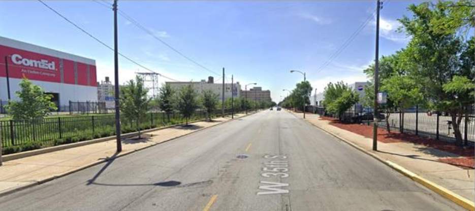
The ComEd Chicago Training Center and Pepsi Beverages are located just east of Ashland Avenue.
Ashland Avenue
Ashland Avenue, from the Stevenson Expressway to the rail line, travels north-south across the community and is home to the area’s densest commercial district at Riverside Square on the northern end, and large vacant industrial buildings and parcels south of 35 th Street, see Figure 7.4.
The corridor has well-maintained and connected sidewalks, on-street parking along the majority of the corridor, and ample parking lots particularly for the number of shopping plazas north of 33 rd Street. The average daily traffic count (ADT) varies between 14,600 and 20,000, with its highest peak at Archer Avenue. Outreach to community residents has identified Ashland Avenue as unsafe for walking and biking due to heavy truck traffic and dangerous crossings, as well as a difficult corridor for driving due to the number of potholes. Future strategies for the plan may explore manners in which pedestrian accessibility is improved, road infrastructure is better maintained, and lot consolidation is considered to provide larger spaces for optimal redevelopment opportunities.
Figure 7.4

Vacant industrial buildings and parcels are common along the east side of Ashland Avenue beginning at 35 th Street and traveling south to the end of the study area.










Log In to comment on this item.
Subscribe
Report
My comments