


The following section synthesizes and summarizes data sources and information collected to assess water quality and flooding in McKinley Park and identifies opportunities to support resilience in the neighborhood.
- Data shows that street flooding poses a substantial risk to properties in the community, particularly north and south of 35th Street. Sources of impairment include a low-lying topography, changing climate, impervious surfaces, and aging sewer infrastructure. Strategies to integrate and promote stormwater management practices will be recommended in the neighborhood plan.
- Of the 169 zip codes that intersect Cook County, zip codes 60608 and 60609 combined had more flood insurance claims than 121 zip codes and claims payout, 2007-2011. The plan will explore ways to achieving resilience, which require making infrastructure, natural systems, and social structures more durable.
Flooding in McKinley Park is not a new problem and dates to the community’s early settlements in the 1850s. Before incorporation, the area near the Illinois and Michigan Canal was purchased and drained by early settlers. Swampy areas near Archer, Ashland, and 35th Street, once known as Mt. Pleasant and nearby Ducktown, were prone to flooding causing residents to build their homes on stilts to avoid it. Figure 10.1 illustrates an example of raised streets in older Chicago neighborhoods as a solution to stormwater management.
The United States Department of the Interior Geological Survey further describes unprecedented flood damage in the South Branch of the Chicago River in 1954. This event likely impacted communities located at the River’s confluence, including McKinley Park. To alleviate flooding, the Sanitary District of Chicago opened the lock gates at the river to allow discharge to Lake Michigan.
The scope and severity of flooding in McKinley Park is well documented. This section summarizes an analysis of regional flood susceptibility data, documented non-emergency flood incident reported calls, and flood damage insurance claims to identify community flood risk.
Regional Flood Susceptibility Index
A key component of flood management is evaluating the vulnerability of flood-prone areas. CMAP developed a flood susceptibility index to identify priority areas across the Chicago region for flood mitigation activities. The Urban Flood Susceptibility Index compares known flood locations to characteristics of the built environment such as impervious cover, topography, combined sewer systems, and the age of buildings to determine whether an area is more or less susceptible to experience urban flooding. Developed areas of the region received a score from 1 (low) to 10 (high).
McKinley Park received a high urban flood susceptibly score due to its location within the City of Chicago’s combined sewer system, the old age of development, and high impervious cover. This presents an opportunity to implement land use interventions, such as green infrastructure practices (e.g., bioswales, complete streets, etc.) in priority areas; community programs and policies (e.g., ordinance updates, education and engagement); and, capital planning to address community flooding.
Non-Emergency Calls
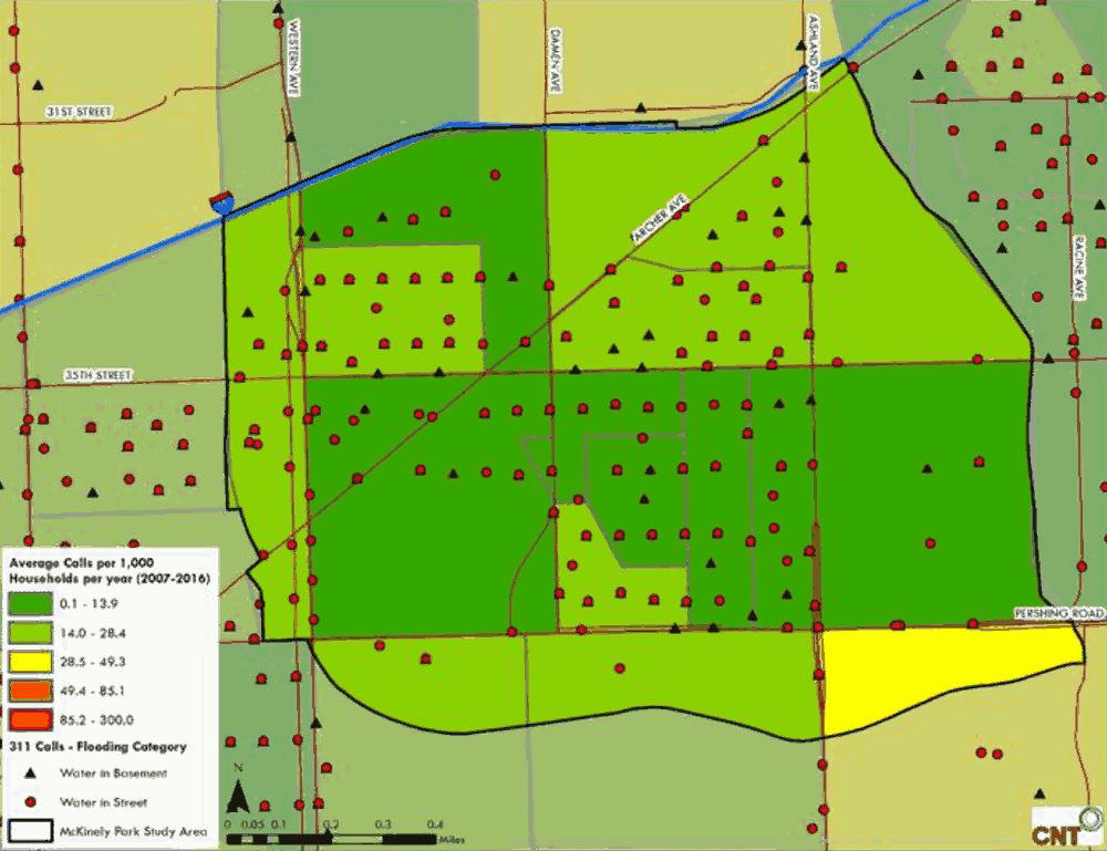
From 2007 to 2016 residents reported flood incidents across the neighborhood. Of the non-emergency calls made by residents, street flooding was widely reported (Figure 10.2), basement flooding less so.
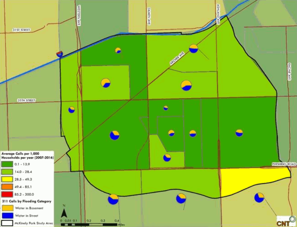
Figure 10.3 represents the ratio of basement flooding versus street flooding reported by residents, with basement flooding more widely reported north of 35th Street, south of I-55, between Western and Ashland Avenues. Residents also reported yard ponding when interviewed during this planning process. It should be noted that 311 reporting varies across the city and should not be the only factor considered to describe the complete problem in a community.
Figure 10.2 Frequency and Types of Flooding Reported in McKinley Park, 311 Calls 2007-2016
Source: Center for Neighborhood Technology, 2018.
Figure 10.3 Ratio of the Types of Flooding Reported in McKinley Park, 311 Calls 2007-2016
Source: Center for Neighborhood Technology, 2018.
Cost and Prevalence of Urban Flooding
The cost and prevalence of flooding in residential homes is well documented. CNT’s analysis of flood damage payouts from private insurance companies and federal disaster relief funds found that McKinley Park zip codes 60608 and 60609 had more than $10 million in damage payouts from 2,904 claims occurring between 2007-2011. McKinley Park’s zip code 60608 was ranked 64th among all 169 Cook County zip codes, in the number of claims and the total value of damages paid to residents. Zip code 60608 had more claims than 121 of the 169 zip codes.
Beyond the direct costs of property damage from flooding (carpets, furniture, and heating units) there are less direct costs. Residents may lose valuable memorabilia. Flooding creates health and safety risks to children, seniors, and animals. Street flooding can damage parked cars and prevent residents from traveling.
In McKinley Park, factors that contribute to urban flooding are familiar to much of the Chicago region: a low-lying topography, a changing climate, development and associated impervious surfaces, and aging sewer infrastructure.
Sewer Infrastructure
McKinley Park is served by the City of Chicago’s sewer system, which was created in 1856. However, many of these sewers were deemed “barely sufficient to drain small areas.” McKinley Park, like much of Chicago, has a combined sewer system that merges stormwater with household sanitary waste. When stormwater overwhelms the sewer system, flooding occurs.
Sewer system infrastructure in McKinley Park requires regular cleaning and repair. The City of Chicago spends $50 million annually to maintain 4,400 miles of sewer lines. The city also supports “green” infrastructure, an approach that incorporates vegetation and other natural elements to manage stormwater and reduce the burden on the sewer system. Chicago’s Cermak/Blue Island Sustainable Streetscape project in Chicago’s Pilsen neighborhood is an example of an innovative green infrastructure approach. The $18 million project includes permeable surfaces, energy efficient street lights, solar panels on lampposts, and a 5.5. wide permeable paved bike lane to capture stormwater.
Changing Climate
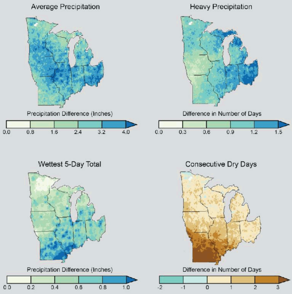
Recent years have been defined by a marked increase in precipitation, particularly the high-intensity, short-duration storms associated with global climate change. The National Climate Assessment (NCA) climate models project an increase in the frequency and intensity of major storms by the middle of the century. Figure 10.4 illustrates modeled precipitation patterns from 2041-2070 relative to observed precipitation from 1971-2000 across the Midwest. The top left and right maps illustrate increases in average and heavy precipitation. The bottom left and right maps illustrate projected increases in rainfall intensity as well as drought.
Figure 10.4. Projected Precipitation Patterns for 2041-2070
Source: NOAA, 2016
According to the National Oceanic Atmospheric Administration, this prediction is already occurring. This increase in precipitation directly correlates to the inability of existing combined sewer infrastructure to handle the increased stormwater flow.
The climate is changing, and McKinley Park residents are experiencing a “new norm” in weather patterns. According to the Illinois State Climatologist, since 2008, the Chicago region, including the McKinley Park, has experienced four storms in six years exceeding rainfall amounts of a “10-year storm.” This type of storm typically brings 4.96 inches of rain over a 2-year period and characteristically occurs once every ten years. On July 22-23, 2011, Chicago experienced a “100-year storm” brining a total of 8.41 inches of rainfall, the largest single day of rainfall since 1871. On April 17-18, 2013, Chicago experienced a “10-year storm,” with 5.5 inches of rainfall.
Low-Lying Topography
The McKinley Park neighborhood is located at a confluence in the South Branch of the Chicago River. The South Fork of the South Branch of the Chicago River, nicknamed “Bubbly Creek” sits at approximately 580 feet above sea level. Portions of McKinley Park, including Bubbly Creek and the western and eastern portions of the neighborhood, lie at the lowest topographical points of neighborhoods surrounding McKinley Park. Properties at a lower elevation often corresponds to a higher flood risk. This, coupled with high impervious cover, presents fewer opportunities to store and infiltrate stormwater.
Development and Impervious Surface
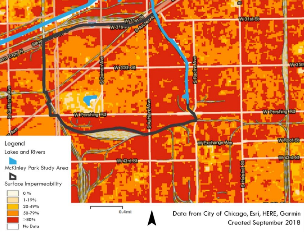
Figure 10.5 characterizes impervious surfaces in McKinley Park. The areas in red are developed with over 80% impervious cover, and the majority are located in industrial areas. As increased precipitation falls on the community, impervious surfaces will generate more stormwater runoff, which pools in yards, overflows streets and backups in basements.
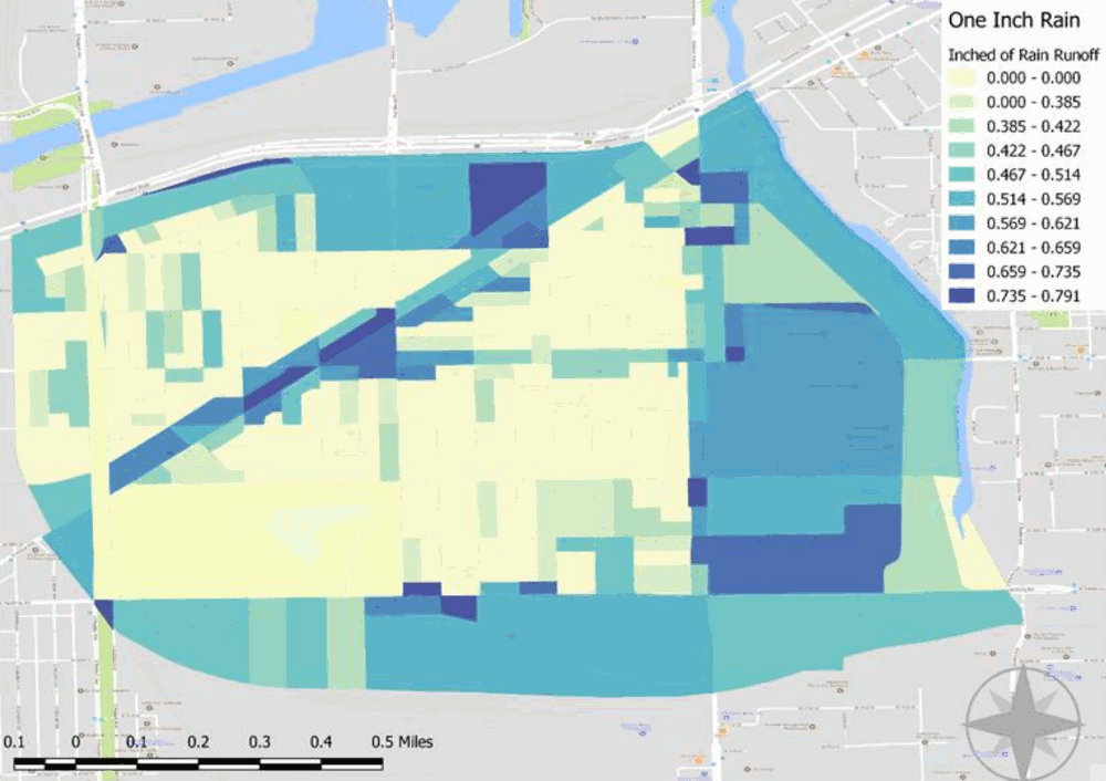
Even small storms can generate a large amount of stormwater. For example, a storm that drops one inch of rainfall on an acre of impervious surface (e.g., a parking lot) would generate 27,154 gallons of stormwater. This is enough runoff to fill over eight backyard swimming pools (at 12 feet round and 48” deep). Figure 10.6 illustrates the amount of runoff in million gallons per neighborhood block based on increasing rainfall amount. If the combined sewer system in McKinley Park is not able to handle this runoff, it could overflow into streets, yards, and basements. Areas with the highest runoff include land along the Archer Avenue commercial corridor and industrial areas in the community.
Just as problematic as the volume of stormwater runoff, are the pollutants this runoff collects as it flows across an urban landscape. Urban surfaces are littered with sediments, debris, oils, road salts, and toxic chemicals. When stormwater runoff transports these pollutants into streams and other waterways, they can degrade aquatic habitats and contaminate water supplies.
Figure 10.5 Impermeability in McKinley Park
Source: CNT
Figure 10.6 Runoff from One-Inch Rain Events in McKinley Park
Source: Center for Neighborhood Technology, 2018.
The City of Chicago offers both a regulatory framework and initiatives that are available to McKinley Park residents experiencing flooding. Many of these are pioneering the use of green infrastructure approaches and have gained national attention. While wide-ranging and often impressive, several of the programs are only partially operational due to funding constraints. A list summarizing the framework and initiatives is identified in Appendix B. If adequately resourced and coordinated, they provide a foundation for addressing urban flooding in McKinley Park.










Log In to comment on this item.
Subscribe
Report
My comments