


The scope and severity of flooding in McKinley Park is well documented. This section summarizes an analysis of regional flood susceptibility data, documented non-emergency flood incident reported calls, and flood damage insurance claims to identify community flood risk.
Regional Flood Susceptibility Index
A key component of flood management is evaluating the vulnerability of flood-prone areas. CMAP developed a flood susceptibility index to identify priority areas across the Chicago region for flood mitigation activities. The Urban Flood Susceptibility Index compares known flood locations to characteristics of the built environment such as impervious cover, topography, combined sewer systems, and the age of buildings to determine whether an area is more or less susceptible to experience urban flooding. Developed areas of the region received a score from 1 (low) to 10 (high).
McKinley Park received a high urban flood susceptibly score due to its location within the City of Chicago’s combined sewer system, the old age of development, and high impervious cover. This presents an opportunity to implement land use interventions, such as green infrastructure practices (e.g., bioswales, complete streets, etc.) in priority areas; community programs and policies (e.g., ordinance updates, education and engagement); and, capital planning to address community flooding.
Non-Emergency Calls
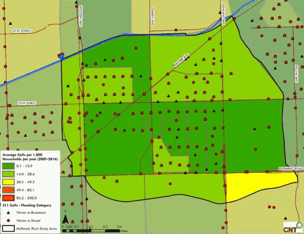
From 2007 to 2016 residents reported flood incidents across the neighborhood. Of the non-emergency calls made by residents, street flooding was widely reported (Figure 10.2), basement flooding less so.
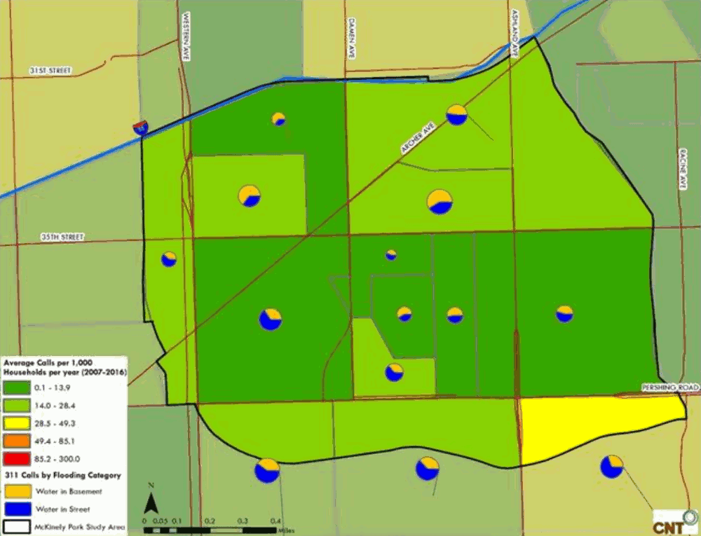
Figure 10.3 represents the ratio of basement flooding versus street flooding reported by residents, with basement flooding more widely reported north of 35th Street, south of I-55, between Western and Ashland Avenues. Residents also reported yard ponding when interviewed during this planning process. It should be noted that 311 reporting varies across the city and should not be the only factor considered to describe the complete problem in a community.
Figure 10.2 Frequency and Types of Flooding Reported in McKinley Park, 311 Calls 2007-2016
Source: Center for Neighborhood Technology, 2018.
Figure 10.3 Ratio of the Types of Flooding Reported in McKinley Park, 311 Calls 2007-2016
Source: Center for Neighborhood Technology, 2018.
Cost and Prevalence of Urban Flooding
The cost and prevalence of flooding in residential homes is well documented. CNT’s analysis of flood damage payouts from private insurance companies and federal disaster relief funds found that McKinley Park zip codes 60608 and 60609 had more than $10 million in damage payouts from 2,904 claims occurring between 2007-2011. McKinley Park’s zip code 60608 was ranked 64th among all 169 Cook County zip codes, in the number of claims and the total value of damages paid to residents. Zip code 60608 had more claims than 121 of the 169 zip codes.
Beyond the direct costs of property damage from flooding (carpets, furniture, and heating units) there are less direct costs. Residents may lose valuable memorabilia. Flooding creates health and safety risks to children, seniors, and animals. Street flooding can damage parked cars and prevent residents from traveling.









Log In to comment on this item.
Subscribe
Report
My comments