


In McKinley Park, factors that contribute to urban flooding are familiar to much of the Chicago region: a low-lying topography, a changing climate, development and associated impervious surfaces, and aging sewer infrastructure.
Sewer Infrastructure
McKinley Park is served by the City of Chicago’s sewer system, which was created in 1856. However, many of these sewers were deemed “barely sufficient to drain small areas.” McKinley Park, like much of Chicago, has a combined sewer system that merges stormwater with household sanitary waste. When stormwater overwhelms the sewer system, flooding occurs.
Sewer system infrastructure in McKinley Park requires regular cleaning and repair. The City of Chicago spends $50 million annually to maintain 4,400 miles of sewer lines. The city also supports “green” infrastructure, an approach that incorporates vegetation and other natural elements to manage stormwater and reduce the burden on the sewer system. Chicago’s Cermak/Blue Island Sustainable Streetscape project in Chicago’s Pilsen neighborhood is an example of an innovative green infrastructure approach. The $18 million project includes permeable surfaces, energy efficient street lights, solar panels on lampposts, and a 5.5. wide permeable paved bike lane to capture stormwater.
Changing Climate
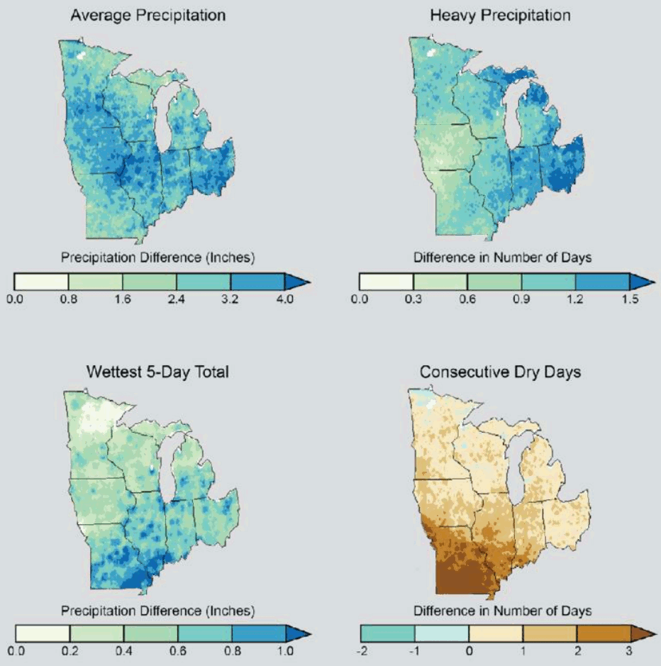
Recent years have been defined by a marked increase in precipitation, particularly the high-intensity, short-duration storms associated with global climate change. The National Climate Assessment (NCA) climate models project an increase in the frequency and intensity of major storms by the middle of the century. Figure 10.4 illustrates modeled precipitation patterns from 2041-2070 relative to observed precipitation from 1971-2000 across the Midwest. The top left and right maps illustrate increases in average and heavy precipitation. The bottom left and right maps illustrate projected increases in rainfall intensity as well as drought.
Figure 10.4. Projected Precipitation Patterns for 2041-2070
Source: NOAA, 2016
According to the National Oceanic Atmospheric Administration, this prediction is already occurring. This increase in precipitation directly correlates to the inability of existing combined sewer infrastructure to handle the increased stormwater flow.
The climate is changing, and McKinley Park residents are experiencing a “new norm” in weather patterns. According to the Illinois State Climatologist, since 2008, the Chicago region, including the McKinley Park, has experienced four storms in six years exceeding rainfall amounts of a “10-year storm.” This type of storm typically brings 4.96 inches of rain over a 2-year period and characteristically occurs once every ten years. On July 22-23, 2011, Chicago experienced a “100-year storm” brining a total of 8.41 inches of rainfall, the largest single day of rainfall since 1871. On April 17-18, 2013, Chicago experienced a “10-year storm,” with 5.5 inches of rainfall.
Low-Lying Topography
The McKinley Park neighborhood is located at a confluence in the South Branch of the Chicago River. The South Fork of the South Branch of the Chicago River, nicknamed “Bubbly Creek” sits at approximately 580 feet above sea level. Portions of McKinley Park, including Bubbly Creek and the western and eastern portions of the neighborhood, lie at the lowest topographical points of neighborhoods surrounding McKinley Park. Properties at a lower elevation often corresponds to a higher flood risk. This, coupled with high impervious cover, presents fewer opportunities to store and infiltrate stormwater.
Development and Impervious Surface
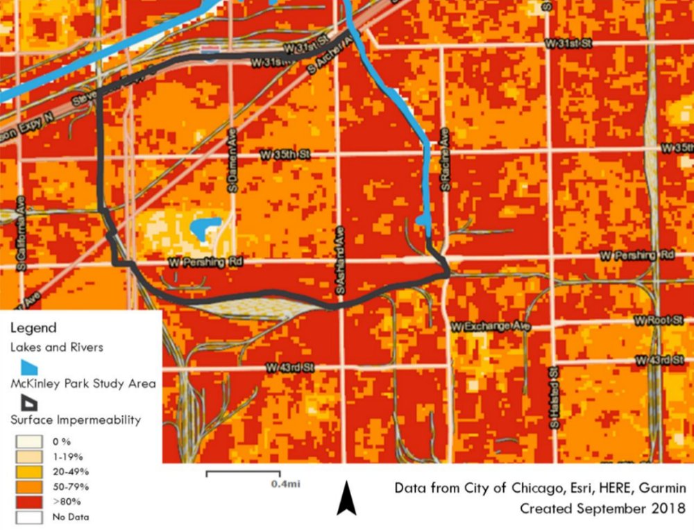
Figure 10.5 characterizes impervious surfaces in McKinley Park. The areas in red are developed with over 80% impervious cover, and the majority are located in industrial areas. As increased precipitation falls on the community, impervious surfaces will generate more stormwater runoff, which pools in yards, overflows streets and backups in basements.
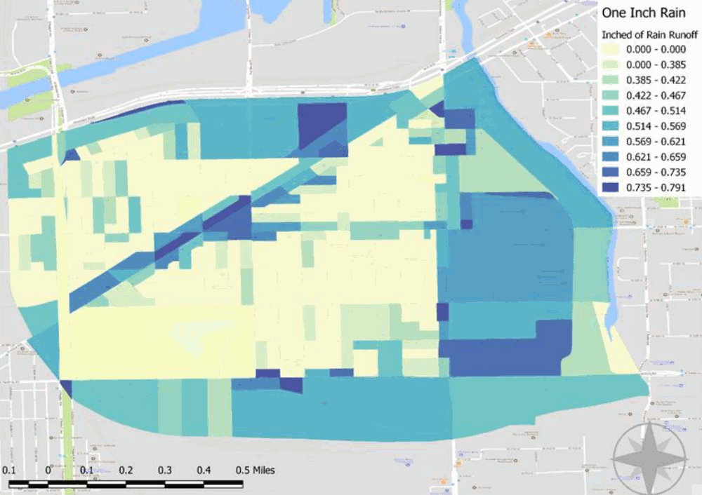
Even small storms can generate a large amount of stormwater. For example, a storm that drops one inch of rainfall on an acre of impervious surface (e.g., a parking lot) would generate 27,154 gallons of stormwater. This is enough runoff to fill over eight backyard swimming pools (at 12 feet round and 48” deep). Figure 10.6 illustrates the amount of runoff in million gallons per neighborhood block based on increasing rainfall amount. If the combined sewer system in McKinley Park is not able to handle this runoff, it could overflow into streets, yards, and basements. Areas with the highest runoff include land along the Archer Avenue commercial corridor and industrial areas in the community.
Just as problematic as the volume of stormwater runoff, are the pollutants this runoff collects as it flows across an urban landscape. Urban surfaces are littered with sediments, debris, oils, road salts, and toxic chemicals. When stormwater runoff transports these pollutants into streams and other waterways, they can degrade aquatic habitats and contaminate water supplies.
Figure 10.5 Impermeability in McKinley Park
Source: CNT
Figure 10.6 Runoff from One-Inch Rain Events in McKinley Park
Source: Center for Neighborhood Technology, 2018.










Log In to comment on this item.
Subscribe
Report
My comments