


The McKinley Park Neighborhood Plan presents a framework for future decision-making rooted in the community’s vision. It is the result of two years of work led by the McKinley Park Development Council (MPDC), Chicago Department of Planning and Development (DPD), and the Chicago Metropolitan Agency for Planning (CMAP) with McKinley Park’s residents, business and property owners, workers, and community leaders.
Located on the southwest side of Chicago, McKinley Park is less than five miles from Chicago’s Loop. For this planning effort, MPDC chose the planning area boundaries defined by the McKinley Park Chicago Community Area, with the exception of its south boundary, which is extended south to the rail corridor to include Chicago’s Central Manufacturing District (CMD). The CMD was the first planned manufacturing district in the United States and one of the largest industrial parks in the world. It includes two CTA Orange Line stations (35th and Archer, and Halsted) that serve the neighborhood; three main commercial corridors: the Archer Avenue, Ashland Avenue, and 35th Street; and the South Branch of the Chicago River.
This Plan is a distillation of CMAP’s research, findings, and recommendations for Chicago’s McKinley Park neighborhood. The plan is organized into the following chapters:
- Executive Summary
- Chapter 1. Introduction
- Chapter 2. A Vision for McKinley Park
- Chapter 3. Preserve Neighborhood Diversity
- Chapter 4. Promote Equitable Transit-Oriented Development
- Chapter 5. Revitalize Commercial Corridors
- Chapter 6. Modernize the Central Manufacturing District
- Chapter 7. Enhance and Expand Parks and Recreational Opportunities
- Chapter 8. Create a Resilient Community
- Chapter 9. Implementation
- Appendix A. Key Intersection Improvement Concepts
- Appendix B. Existing Conditions Report
- Appendix C. Outreach Activities and Results
Each of the bolded chapters represents a goal. Each chapter includes a vision statement, highlights of key findings, and a set of recommendations followed by an implementation table that provides a description of actions to be undertaken. Appendix A provides conceptual drawings for potential improvements at six key intersections in the study area. Appendix B is the Existing Conditions Report, an interim deliverable for this plan that summarizes current conditions in the area at the outset of the planning process and identifies issues and opportunities for the plan to address. Appendix C includes summaries of all the outreach activities and results throughout the process.
McKinley Park is a working-class neighborhood located on Chicago’s southwest side. Throughout its long history, McKinley Park has served as an important industrial job center. Its strong transportation network and proximity to the South Branch of the Chicago River speak to the neighborhood’s history as a thriving industrial center. Today, McKinley Park’s location continues to play an important role. Its proximity to multimodal transportation options, parks and open space, as well as regional economic centers bolster its potential as a desirable location for residential and commercial investment. However, like many neighborhoods in Chicago, McKinley Park wrestles with reduced housing affordability, disinvested corridors, and unattractive vacancies.
McKinley Park has never had its own plan to guide development in ways that align with community priorities. The neighborhood plan presents a unified vision of what the community aspires to be and provides a roadmap to achieve that vision. This vision of what could be is what inspired MPDC to produce a neighborhood plan that builds upon the community’s valuable assets, as well as past and current planning efforts, to complement and continue these endeavors.
While the focus of the plan is McKinley Park, the plan also acknowledges planning activities in adjacent communities, including Pilsen, Bridgeport, Back of the Yards, and Brighton Park. Key areas of emphasis for the plan include, but are not limited to, equitable transit-oriented development, revitalization of commercial corridors, modernization of the CMD, as well as climate resilience.
In early 2018, MPDC began a community-driven process to create their first ever neighborhood plan as part of CMAP’s Local Technical Assistance (LTA) program. The process to create this plan included multiple steps that were undertaken over approximately two years. The planning process was crafted with assistance from MPDC, DPD, and the Center for Neighborhood Technology (CNT), and was designed to include input from residents, stakeholders, and business owners throughout. This plan outlines the community’s shared vision and defines policies and steps to help achieve that vision.
One of the primary goals of the Neighborhood Plan planning process was to fully and effectively engage the community. McKinley Park is one of the most racially and ethnically diverse communities in the City of Chicago. To provide mechanisms for meaningful outreach in such a diverse community, CMAP staff devised a public outreach strategy with MPDC and the steering committee to execute several approaches for public participation. The project team used one-on-one confidential interviews, steering committee meetings, a focus group, listening meetings, and an interactive online survey, and also attended several events and meetings in the community.
The outreach efforts had five major goals:
- Engage a broad representation of the community in the planning process.
- Educate the community about the purpose of the project.
- Garner public input on key issues and opportunities for McKinley Park.
- Create a shared vision for McKinley Park.
- Build community capacity to implement the plan.
Outreach Results
Figure 1. McKinley Park Area Study Context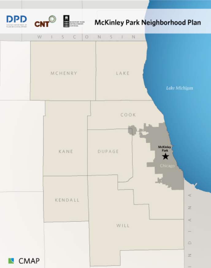 More than 820 residents and stakeholders have contributed their input since the start of the formal planning process. Overall, participants held many of the same concerns and generally expressed the desire to build upon the many assets of the neighborhood. Most participants want to maintain the industrial heritage of the neighborhood but also expressed health and nuisance concerns related to those uses. The new asphalt plant rose as a major concern related to environmental quality and highlighted the need for improved transparency in the development approval process. The community envisions a new direction for industrial uses and sees public engagement in the development process essential to realizing that vision.
Longtime residents reported their desire to preserve the close-knit and diverse culture that exists in their community. Gentrification and displacement were identified as priority concerns, and residents stressed the importance of preserving housing affordability to combat displacement. Stakeholders mentioned the need to support local businesses, particularly along 35th Street, and prioritize economic development along main commercial corridors.
Safety for those walking and biking in the neighborhood is a primary concern, particularly along high-traffic-corridors like Archer Avenue. Many people would like to see designated bike lanes and trails for active transportation, as well as streetscape improvements for pedestrians. Community-based programming for all ages was also a key priority for many residents.
In addition, many stakeholders would like to capitalize on their neighborhood parks, connection to the boulevard system, and proximity to the river to promote livability and attract residents, visitors, and shoppers to the neighborhood. Photos from outreach events are found in Appendix C.









Log In to comment on this item.
Subscribe
Report
My comments