


MPDC is leading a process to develop a neighborhood plan that builds upon McKinley Park’s assets and complements past and current planning efforts. This plan will outline the community’s vision for the future of McKinley Park, pinpoint the issues and opportunities that need to be addressed to achieve that vision, and identify strategies to address those issues and opportunities in the community.
Having an accurate understanding of the existing conditions of the community is necessary to develop an effective plan. This section provides an overview of the current conditions in McKinley Park and is designed to provide an agreed upon starting point by which to move forward and create a shared vision. Crafted with assistance from MPDC, the planning process will last approximately 18-24 months and is designed to include input from residents, businesses, and other stakeholders throughout.
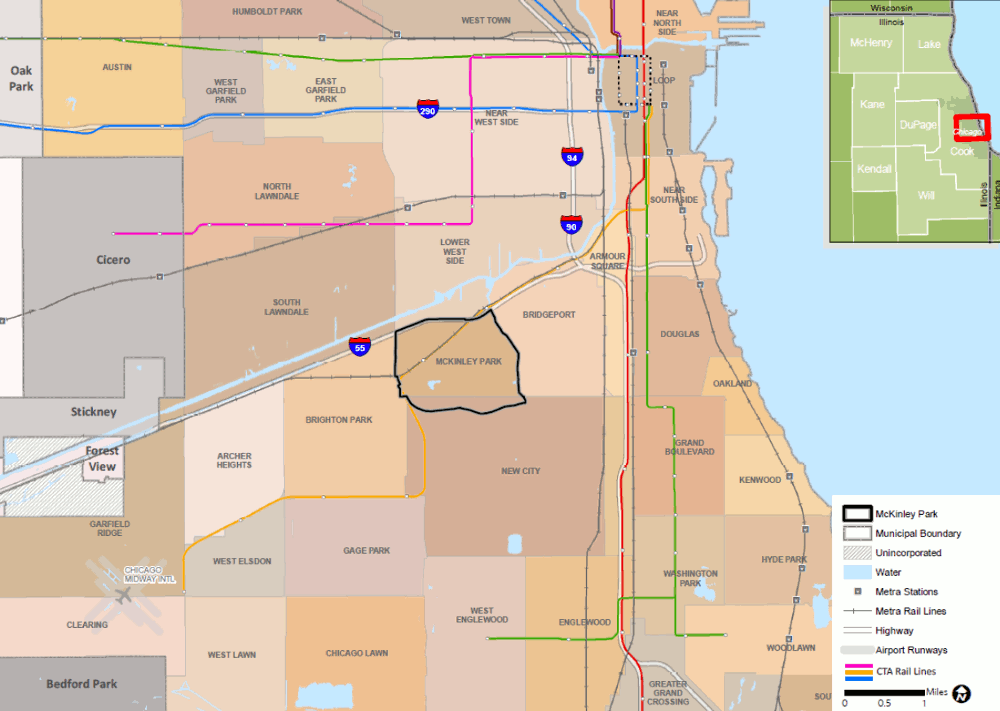
Figure 2.1 McKinley Park Study Area and Regional Context

Source: Chicago Metropolitan Agency for Planning, 2018
Located in Cook County, on the southwest side of the City of Chicago, McKinley Park is less than five miles from Chicago’s Loop. Neighboring communities include Bridgeport, Back of the Yards, Brighton Park, South Lawndale, and Lower West Side. The Stevenson Expressway (I-55) is north of McKinley Park, connecting the western suburbs to the Chicago Loop. The planning area boundaries are defined by the McKinley Park Chicago community area, with the exception of its south boundary, which is extended south to the rail corridor to include the CMD (see Figure 2.1). It includes two CTA Orange Line stations that serve the neighborhood, three main commercial corridors: the Archer Avenue, Ashland Avenue, and 35th Street Commercial Corridors, and the South Branch of the Chicago River.
Figure 2.2 McKinley Park Study Area Context
Source: Chicago Metropolitan Agency for Planning, 2018
Understanding the governmental structure within McKinley Park will allow plan recommendations to be crafted and tailored to the appropriate partners and implementers. As in all Chicago neighborhoods, many city services and investments are coordinated by local aldermen. The planning area is contained almost entirely within the 12th Ward, which is represented by Alderman George A. Cardenas. A small portion of McKinley Park is also located in the 11th Ward (Alderman Patrick D. Thomson). Alderman Cardena’s office is located in the study area at 3476 S. Archer Avenue.
The Chicago Police Department serves the neighborhood through its 9th district, located at 3120 S. Halsted Street. Fire protection is provided through the Chicago Fire Department. Engine Company 39 is located within the study area at 33rd Place and Ashland Avenue. Additional fire services are provided by a Special Operations Division located in the CMD at 3918 S. Honore Street.
Residents in McKinley Park have access to an array of amenities, including those provided by the Chicago Park District and the McKinley Park Branch of the Chicago Public Library. The library provides an array of resources and services, with community space and programs for all ages. Additionally, the library features Chinese-language and Spanish-language materials and a “Citizens Corner” that offers English as a Second Language classes, citizenship workshops and a wide selection of materials on immigration and U.S. citizenship. Information about amenities and services provided by the Chicago Park District is available in Section 9 of this report.
McKinley Park has four public, two charter, and three private schools. Five colleges and universities are near McKinley Park, including the Arturo Velazquez Westside Technical Institute, Rush Medical College, Illinois Institute of Technology, and the University of Illinois at Chicago.
Cook County Board of Commissioners
The Cook County Board of Commissioners is the governing board and legislative body of the county. It is composed of 17 Commissioners, elected from single member districts to four-year terms. Each district represents approximately 300,000 residents. The Board of Commissioners is responsible for the management of the affairs of Cook County. McKinley Park is located in Cook’s 7th District and is represented by Commissioner Alma E. Anaya. Commissioner Anaya’s offices are located at 3520 S. Archer Avenue.
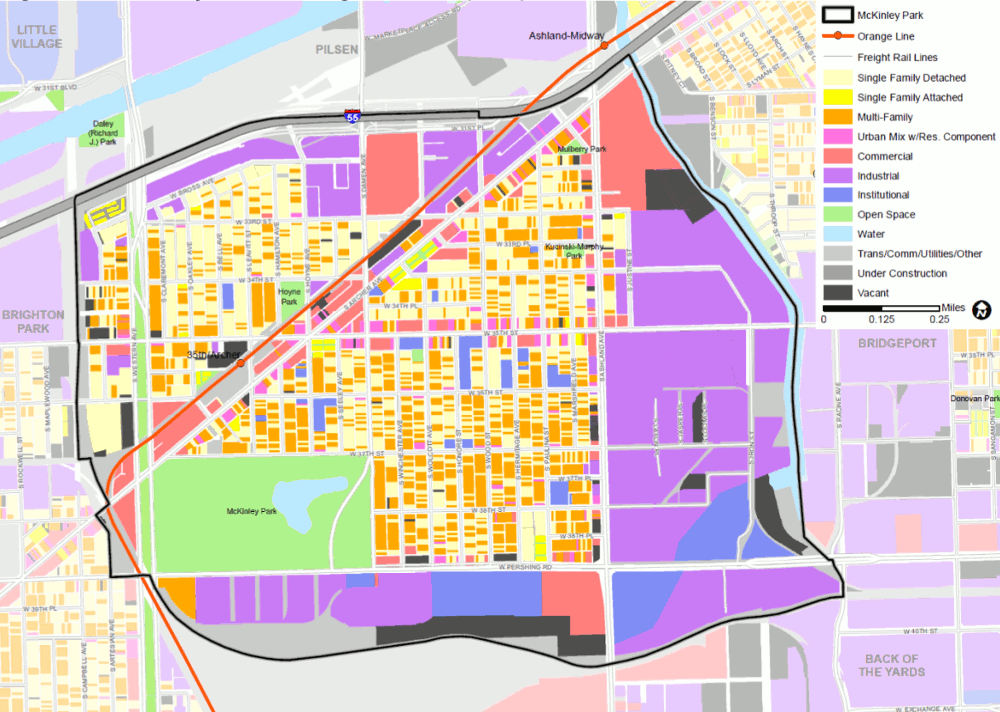
Livable communities depend on a mix of land uses that provide the homes, jobs and businesses, civic institutions, and open space that are essential for daily living. An assessment of the existing land use pattern in McKinley Park provides a foundational understanding of what is in the community now and how that could change in the future (Figure 2.3 and Table 2.1).
The largest portion of the land area in McKinley Park is devoted to residential dwellings (28.2 percent), nearly evenly split between single-family homes (14.7 percent) and multi-family uses (13.5 percent). Single-family and multi-family housing intermixes throughout the community with most multi-family development consisting of two story buildings. Mixed-used properties containing residential units, typically on the second floor, constitute 1.3 percent of the land use and are generally located along 35th Street and Archer Avenue, and in the southeastern portion of the community.
The second largest portion (26.6 percent) of the total land area in the study area is dedicated to industrial uses. These land uses include the historic CMD and two Planned Manufacturing Districts (PMDs), which are found along the south and east borders of McKinley Park, near major railroads and the South Branch of the Chicago River. Significant industrial uses are also located on the north border of the community near I-55.
Table 2.1 McKinley Park Study Area Existing Land Use, 2013
| Land Use | Acres | Percent |
| Single-Family Residential | 120.14 | 14.7% |
| Multi-Family Residential | 110.53 | 13.5% |
| Commercial | 71.79 | 8.8% |
| Mixed Use | 11.82 | 1.4% |
| Industrial | 217.43 | 26.6% |
| Institutional | 50.47 | 6.2% |
| Transportation/Communications/Utility | 94.73 | 11.6% |
| Open Space | 75.08 | 9.2% |
| Water | 10.3 | 1.3% |
| Vacant | 53.81 | 6.6% |
| Total | 816.1 | 100% |
Source: CMAP 2013 Land Use Inventory
*Includes updates based on May 2018 field reconnaissance.
Commercial development in McKinley Park is concentrated along major corridors —Archer Avenue, 35th Street, and Ashland Avenue. As the most prominent arterial in the study area, Archer Avenue provides the majority of this commercial land, with nearly 53 acres of commercial property directly adjacent to it.
Institutional uses are generally distributed throughout the community and include large city-owned properties located in the CMD and the southeastern portion of the study area. Existing transportation, communications, and utility uses make up 11.6 percent of the land and include transit stations and rail lines, as well as public streets and sidewalks. Open space makes up nine percent of McKinley Park’s total land area. The majority of the open space is located within the 69-acre McKinley Park and the Western boulevard system, which are maintained by the Chicago Park District. More information about Parks and Open Space is available in Section 9 of this report.
Figure 2.3 McKinley Park Existing Land Use (2013)
Source: Chicago Metropolitan Agency for Planning, 2018.
Zoning and other development regulations play an important role in determining the form and character of existing and future development. Updating development regulations to be consistent with a community’s land use vision is often a critical step to implementing a neighborhood plan.
Understanding the composition of the community and demographic trends will help local organizations and community stakeholders respond to the needs of its existing residents as well as prepare for potential changes. The demographics of the larger Chicago region are expected to shift substantially over the next three decades; similar changes are anticipated in the McKinley Park community.
After experiencing significant population decline for most of the twentieth century, McKinley Park grew sharply in the 1980s and 90s, before stabilizing since that time.
On average, McKinley Park’s families are larger and its population is younger than elsewhere in the Region and Chicago. The average household size in McKinley Park was 3.1 individuals in 2016 which is approximately 21 percent larger than that of Chicago or the region (see Table 2.2). Similarly, 27.5 percent of the McKinley Park 2016 population was under 19 years of age compared to just 24.5 percent and 26.4 percent in Chicago and the Region respectively.
Table 2.2 Population and Households, 2000 - 2016
| McKinley Park | Chicago | CMAP Region | |
| Population, 2016 | 16,064 | 2,714,017 | 8,501,507 |
| Population, 2000 | 15,962 | 2,896,016 | 8,146,264 |
| % Population Change, 2000-16 | 0.6% | -6.3% | 4.4% |
| Average Household Size, 2016 | 3.1 | 2.5 | 2.7 |
| Median Income, 2016 | $43,496 | $50,434 | $65,174 |
Source: CMAP analysis of the 2000 U.S. Decennial Census data and American Community Survey five year estimates for 2012-2016.
Table 2.3 Age Cohorts and Median Age, 2016
| McKinley Park | Chicago | CMAP Region | ||
| Count | Percent | Percent | Percent | |
| Youth (under 19 years) | 4,424 | 27.5% | 24.5% | 26.4% |
| Adults (20 to 64 years) | 10,016 | 62.3% | 64.2% | 60.9% |
| Older Adults (65 years and over) | 1,624 | 10% | 11.2% | 12.6% |
| Median Age* | 33.4 | 33.9 | 36.7 | |
Source: CMAP analysis of American Community Survey five year estimates for 2012-2016.
*Note that all CCA & regional medians were estimated using grouped frequency distributions.
Race and Ethnicity
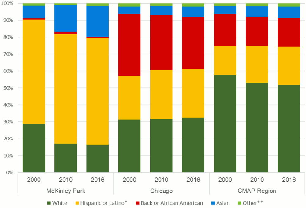
Self-reported data on race and ethnicity indicates that the study area features relatively large populations of Latino and Asian residents. In 2016, the study area’s racial and ethnic composition included a mix of 62.8 percent Latino, 18.2 percent Asian, 16.6 percent White, and 0.9 percent African American. This racial composition differs from that of the city, as well as that of the region.
Between 2000 and 2016, the White population of the study area decreased from 4,607 to 2,660 (or 42.3 percent). During this same period, the Black or African American population decreased by 25 percent. Meanwhile, the Latino/Hispanic population increased slightly by 2.8 percent while the Asian population increased significantly by 140.8 percent.
Figure 2.4 Race and Ethnicity in McKinley Park, Chicago, and CMAP Region, 2000 - 2016
Source: CMAP analysis of U.S. Decennial Census data 2000, 2010, and American Community Survey five year estimates for 2012-2016.
Table 2.4 Race and Ethnicity by Select Community Areas, 2016
| McKinley Park | Bridgeport | New City | Brighton Park | South Lawndale | Lower West Side | |
| White | 16.6% | 33.4% | 12.1% | 6.3% | 3.4% | 15.0% |
| Hispanic or Latino* | 62.8% | 24.9% | 61.5% | 84.7% | 84.0% | 77.9% |
| Back or African American | 0.9% | 2.6% | 23.1% | 1.0% | 11.9% | 3.8% |
| Asian | 18.2% | 37.2% | 2.4% | 7.4% | 0.3% | 2.2% |
| Other** | 1.5% | 1.9% | 1.0% | 0.6% | 0.4% | 1.1% |
Source: CMAP analysis of American Community Survey five year estimates for 2012-2016.
* Includes Hispanic or Latino residents of any race.
** Includes American Indian and Alaska Native, Native Hawaiian and Other Pacific Islander, some other race, and two or more races.
Ancestry and Language
The neighborhood’s vast racial and ethnic diversity is evident in the wide range of languages spoken in McKinley Park and the many different countries of origin among foreign-born residents. Spanish is the most common non-English language, reflecting the large numbers of immigrants from Latin America. Many Asian and European languages are also spoken in the area, including Chinese, Polish, and Korean. The extent and importance of the neighborhood’s cultural and linguistic diversity is discussed in greater depth in Section 4.
A balanced housing supply helps to ensure that households of all income and age groups have access to the assets in McKinley Park and the larger Chicago region. A mix of housing types is needed to allow residents to age in place and provide homes for members of the community as their housing needs change. Understanding the current housing supply as well as potential future demand will help McKinley Park develop a balanced mix of housing that serves current and future populations and enhances livability.
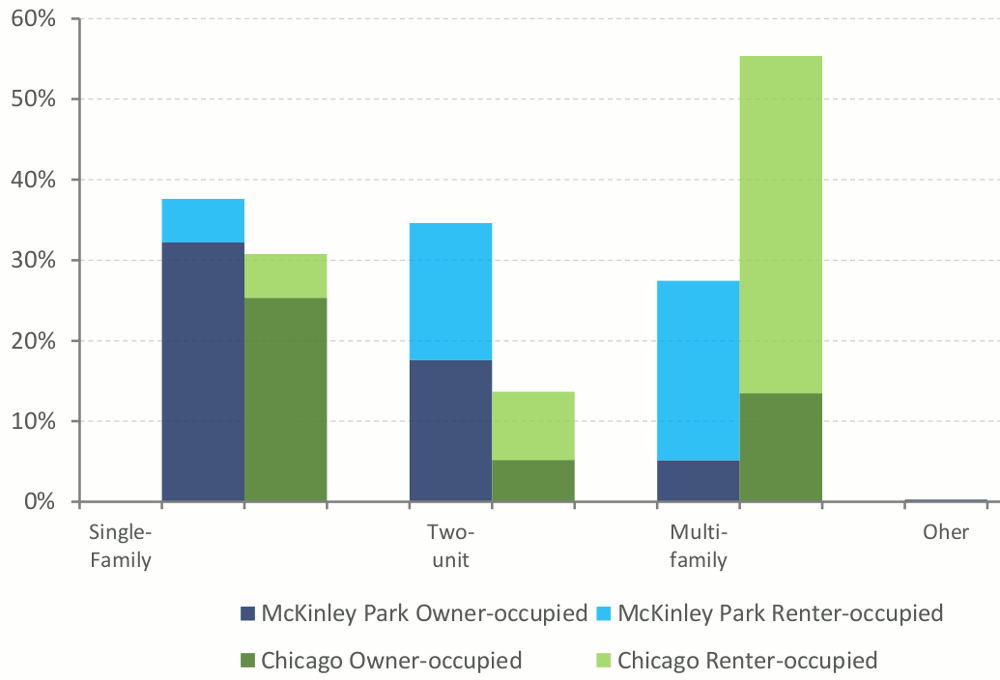
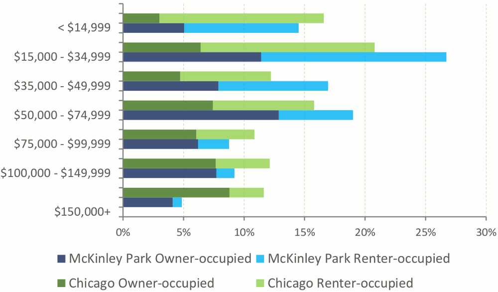
Approximately 72 percent of housing units in McKinley Park are single-family or two-flat multi-family compared to 44.4 percent in the City of Chicago (see Table 2.5). The study area has a larger share of owner-occupied than the city as a whole, approximately 55.3 percent of households are owner-occupied and 44.7 percent are renter-occupied. The opposite is true for Chicago where 44 percent of households are owner-occupied and 56 percent are renter occupied. McKinley Park has more households in the middle-income brackets than the City of Chicago (see Figure 2.5). The proportion of owner-occupied units is also higher than in Chicago in every income bracket except for those households making more than $150,000 a year, see Figure 2.6. Renter-occupied units are slightly similar in proportion (33.8 percent) in these lower income brackets compared to Chicago (35.4 percent).
Table 2.5 Housing Type (Units) by Community Area, 2016
| McKinley Park | Bridgeport | New City | Brighton Park | South Lawndale | Lower West Side | ||
| Count | Percent | Percent | Percent | Percent | Percent | Percent | |
| Single-family | 2,032 | 36.3% | 30.6% | 25.1% | 25.5% | 19.8% | 13.5% |
| Two units | 2,011 | 36.0% | 24.7% | 39.4% | 46.4% | 37.8% | 25.2% |
| Multi-family 3 - 4 Units | 923 | 16.5% | 28.5% | 26.2% | 24.9% | 28.8% | 32.0% |
| Multi-family 5+ units | 610 | 10.9% | 16.1% | 9.1% | 2.9% | 13.3% | 29.2% |
Source: CMAP analysis of American Community Survey five year estimates for 2012-2016.
Figure 2.5 Housing Type by Owner/Renter in McKinley Park and Chicago, 2016
Source: CMAP analysis of American Community Survey five year estimates for 2012-2016.
Figure 2.6 Owner/Renter by Household Income in McKinley Park and Chicago, 2016
Source: CMAP analysis of American Community Survey five year estimates for 2012-2016.
In order to prosper economically and sustain a high quality of life, McKinley Park and the Chicago region need to maintain a diversity of business types, a skilled workforce, and modern infrastructure. Industrial, retail, and office development in McKinley Park are influenced by trends within the community, but also the larger sub-regional and regional markets for each sector. This section provides an overview of this larger economic development context to ensure McKinley Park stakeholders move forward with a plan that reflects market realities.
Employment
According to 2015 data from the Longitudinal Employer-Household Dynamics (LEHD) – a program of the Center for Economic Studies at the U.S. Census Bureau – nearly 5,109 people work in the study area, which was a 15.3 percent decrease from 2005. The largest employment sectors in the study area were administration and support with 1,486 jobs, and wholesale trade with 829 jobs. Historically an industrial hub, manufacturing, transportation and warehousing businesses provide 18.6 percent of jobs.
The fastest growing job sector in the community was educational services (which grew by 1200 percent), followed by professional services (+204.8 percent), and wholesale trade (+68.2 percent). However, some sectors saw significant declines between 2005 and 2015; manufacturing employment, for example, declined from 2,352 to 566 jobs.
According to the 2016 American Community Survey five-year estimates, residents of McKinley Park had an unemployment rate of 12.5 percent, which is higher than the rates experienced citywide (10.9 percent) and region wide (8.4 percent).
Table 2.6 Employment (Primary Jobs) in McKinley Park, 2005-2015
| McKinley Park | Chicago | CMAP Region | |
| Employment, 2005 | 6,029 | 1,068,416 | 3,476,153 |
| Employment, 2015 | 5,109 | 1,234,954 | 3,788,375 |
| Change, 2005-15 | -920 | 166,538 | 312,222 |
| Change as %, 2005-15 | -15.3% | 15.6% | 9.0% |
Source: CMAP analysis of Longitudinal Employer-Household Dynamics, U.S. Census
Table 2.7 Total Employment in the Community and of Residents, 2015
| EMPLOYMENT IN THE COMMUNITY | ||
| By Top Ten Industry Sector | Count | Percent |
| Administration and Support | 1,486 | 29.1% |
| Wholesale Trade | 829 | 16.2% |
| Retail Trade | 738 | 14.4% |
| Manufacturing | 566 | 11.1% |
| Transportation and Warehousing | 383 | 7.5% |
| Accommodation and Food Services | 340 | 6.7% |
| Finance and Insurance | 171 | 3.3% |
| Professional Services | 128 | 2.5% |
| Other Services | 109 | 2.1% |
| EMPLOYMENT OF RESIDENTS | ||
| By Top Ten Industry Sector | Count | Percent |
| Accommodation and Food Services | 730 | 12.9% |
| Health Care and Social Assistance | 615 | 10.8% |
| Manufacturing | 613 | 10.8% |
| Administration and Support | 566 | 10.0% |
| Retail Trade | 529 | 9.3% |
| Educational Services | 448 | 7.9% |
| Professional Services | 399 | 7.0% |
| Wholesale Trade | 306 | 5.4% |
| Finance and Insurance | 279 | 4.9% |
| Transportation and Warehousing | 245 | 4.3% |
Source: Longitudinal Employer-Household Dynamics, U.S. Census, 2015.
Commercial and Industrial Property
Industrial buildings are primarily located along Pershing Road, Ashland Avenue (to the river), and on 33rd Street to the I-55. Office buildings are concentrated at the intersection of 35th Street and Archer Avenue. Retail buildings are located along a “commercial triangle” composed of Archer Avenue, 35th Street, and Ashland Avenue. Please see Section 8 for a detailed analysis of commercial and industrial properties in the study area.
Recent Developments
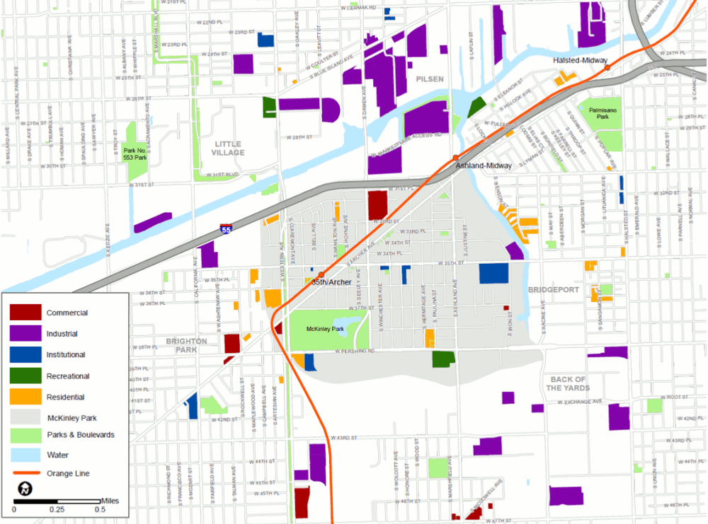
Since 2000, McKinley Park has seen several developments that have ranged in location and use, mostly residential, institutional, and manufacturing. Many of the new industrial projects are located along the Chicago River and rail lines. Completed in 2015, ComEd’s Chicago Training Center is the largest McKinley Park development in the last 17 years. New residential developments include the addition of 3211 S. Hamilton, Oakley Terrace, McKinley Park Lofts, and McKinley Gardens. The only major commercial development has been the Target at 31st Street and Damen Avenue, completed over a decade ago.
Figure 2.7 McKinley Park Recent Developments
Source: Chicago Metropolitan Agency for Planning, 2018.
Municipal Revenue and Real Estate
Ideally, local development decisions should make effective use of land, generate good jobs, and trigger sustainable economic development. To achieve this, local revenue streams must sustain public services and infrastructure investments that attract and retain both residents and businesses. When making decisions regarding the types and balance of revenue that will be used to fund public services, communities must also consider other issues such as quality of life, community, and economic development needs.
While Equalized Assessed Value (EAV) data reflect the residential character of McKinley Park, they also highlight the community as an employment destination anchored by the industrial corridor that runs along the eastern and southern edges of the community.
McKinley Park’s revenue stream is primarily derived from its residential properties which account for nearly 60 percent of the estimated EAV. Commercial and Industrial properties almost make up the rest of the EAV with 18 and 19 percent, respectively (Table 2.9). Unlike the City of Chicago, McKinley Park’s industrial properties make-up a substantial part of its EAV mix.
Table 2.8 Estimated Equalized Assessed Value (EAV) by Property Type, 2015
| McKinley Park* | Chicago | ||
| Property Type | Estimated EAV | Percent | Percent |
| Residential EAV | 68,913,780 | 57.9% | 61.8% |
| Commercial EAV | 21,576,576 | 18.1% | 35.2% |
| Industrial EAV | 22,771,043 | 19.1% | 2.7% |
| Transportation EAV | 1,850,189 | 1.5% | 0.2% |
| Mixed Use EAV | 3,861,717 | 3.2% | -- |
| Total EAV | 118,973,305 | 99.8% | 99.9% |
Source: Cook County Assessor
*Includes property tax exemptions
Natural resources are some of the greatest assets in McKinley Park as well as the Chicago region. These resources provide a number of ecosystem services, such as clean air and water, habitat and biodiversity, flood control, and climate regulation, among others. In addition, the natural environment contributes to community character and enhances quality of life. McKinley Park’s natural resources exist within a larger network of water and land resources and the community’s plans, policies, and development decisions should work in concert with these assets to achieve a sustainable and livable future.
Green Infrastructure
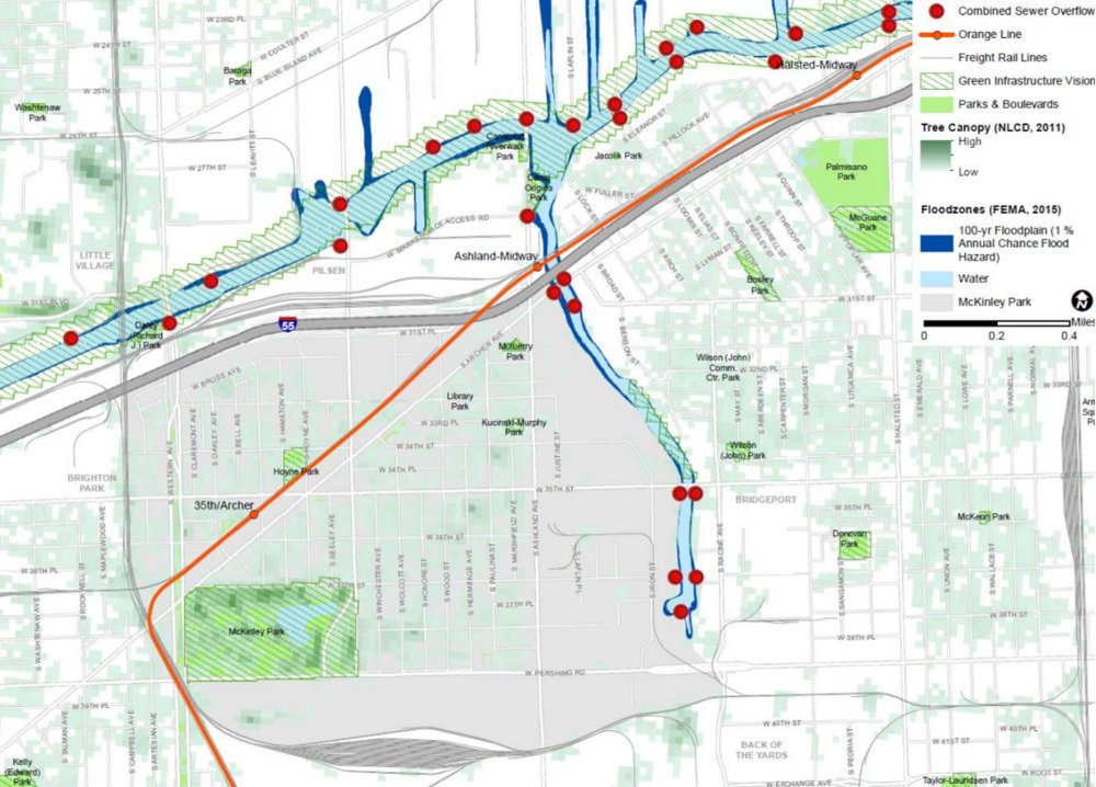
The regional Green Infrastructure Vision (GIV) is a large-scale, multistate vision of interconnected land and water resources and Figure 2.8 illustrates the resources identified at the regional scale for McKinley Park and its extended planning area. Most GIV areas are in neighborhood and community parks including McKinley Park, Hoyne Park, and parts of the Chicago River.
Local Open Space
Residents in McKinley Park have access to approximately 2.6 acres of open space per 1,000 residents. Open Space in McKinley Park is concentrated in the 69-acre McKinley Park, which accounts for the vast majority of open space in the study area. Other parkland spaces include the Western Boulevard, Hoyne Park, Mulberry Park, Kucinski-Murphy Park, and the recently completed Nature Play Garden. Please reference Section 9 of this report for more information on the local open space areas in the community.
Water Source and Supply
Water availability has been a central ingredient to the region’s economic prosperity and may play an even larger role in years to come. The City of Chicago’s Department of Water Management provides Lake Michigan water to McKinley Park.
Storm and Sanitary Sewer System
Maintaining adequate public wastewater sewer infrastructure is vital to public health and clean water. The City of Chicago maintains a combined sewer system that collects both sanitary and stormwater in the same pipe. The city maintains a combined sewer overflow (CSO) permit with the federal National Pollutant Discharge Elimination System (NPDES) permit program. The combined sewers feed into the sub-regional combined sewer system maintained by Metropolitan Water Reclamation District (MWRD), where wastewater is eventually treated at reclamation plants.
The east portion of McKinley Park runs along the South Fork of the Chicago River, which could increase the risk of flooding in the area. Local drainage and sewer systems can become overwhelmed in some locations due to the amount of stormwater runoff leading to localized flooding. Green infrastructure practices can reduce the amount of water flowing into sewers, reduce localized flooding and basement backups, and improve water quality of nearby rivers and streams. During storm events, excess water can flow into the MWRD’s Tunnel and Reservoir Plan (TARP) system for storage. The TARP tunnels are generally located 200 feet below the Chicago River system. Please reference Section 10 of this report for a thorough analysis of flooding in McKinley Park.
Climate Resilience
Climate change has already begun to affect the Chicago region, and will continue to bring more frequent and intense storms, increased periods of extreme heat and cold, and longer droughts. Local impacts may include decreased livability, increased costs to the public sector and private citizens as a result of damage to infrastructure and property, and even loss of life. McKinley Park’s vulnerable populations, such as low-income or the elderly, may be disproportionately burdened by future climate impacts. Such populations may not have access to safe and comfortable living conditions during periods of extreme heat or cold, or might not have the financial resources required to rebound from storm-related property damage.
Figure 2.8 McKinley Park Natural Environment Resources
Source: Chicago Metropolitan Agency for Planning, 2018.
A modern transportation system is indispensable; residents must be able to travel efficiently, easily, and safely around McKinley Park as well as the larger Chicago region to sustain our economy and quality of life. Businesses must be able to count on the timely delivery of their goods. With an aging and congested transportation system and limited funding, strategic maintenance and modernization are necessary to respond to mobility needs and trends.
McKinley Park’s location provides excellent access to the regional transportation network with close proximity to the Stevenson Expressway (I-55), Kennedy Expressway (I-90), freight rail (Atchison Topika and Santa Fe Railroad, Burlington Northern Santa Fe, Central Illinois Railroad, CSX Transportation, and the Northfolk Southern Railroad), the CTA Orange Line, and six CTA bus routes. There are several on-street bicycle facilities, including bike racks, six Divvy stations, and designated bikeways along Pershing Road and Western Avenue (Figure 2.8).
Commuting in McKinley Park
Traveling to and from work is often the largest component of an individual’s travel behavior. Only 3.1 percent of 5,670 employed McKinley Park residents both live and work in the study area; the remaining 96.9 percent work outside the neighborhood. Nevertheless, the great majority of McKinley Park’s labor force works close by – 72.4 percent of employed residents work within 10 miles from the study area, and 19 percent work 10 to 24 miles away.
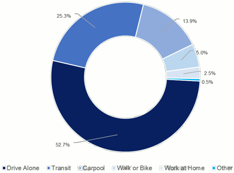
Fifty-three percent of McKinley Park residents drive to work alone, and 25 percent take transit for their daily commute, 14 percent carpool, five percent use active transportation, and almost three percent work from home (Figure 2.9).
Figure 2.9 Commute Mode Share for McKinley Park Residents
Source: CMAP analysis of American Community Survey five year estimates for 2012-2016.
Conditions for Pedestrians and Cyclists
Walkability was cited by many as one of the most important factors in the health and vitality of the community. Sidewalks are prevalent on both sides of streets throughout residential and commercial areas of McKinley Park. However, high traffic levels, vacant parcels, and a lack of street trees along main commercial corridors can make walking unsafe and uninviting. McKinley Park’s core areas have complete crosswalks at most intersections, including signalized crosswalks at major intersections. While most sidewalks throughout the community are walkable and well maintained, Archer Avenue and Ashland Avenue can be difficult to cross due to its wide right-of-way and fast-moving traffic. The segment of the study area east of Ashland Avenue was an area of concern to residents given the lack of sidewalks and access to the river.
Additionally, many viaducts that run below the rail tracks adjacent to Archer Avenue are in various states of disrepair, often creating an uninviting environment for both pedestrians and cyclists. These viaducts are owned and maintained by private rail companies and not the city or federal government. This presents additional challenges to improve the conditions of these viaducts, as many improvements would need to be done in coordination with those private parties.
Many people ride bikes for transportation and recreation in McKinley Park. The 12th Ward Alderman’s office coordinates an annual family bike event that brings together many local cyclists and visitors. The McKinley Park Kidical Mass is also a very active group in the community. Designated bike routes can be found along Pershing Road between Western Avenue and Ashland Avenue; and south of Archer Avenue from Western Avenue and north of Western Avenue from Archer Avenue. Some community members noted that cycling on Archer Avenue can be difficult due to its higher traffic speeds. But biking conditions along Archer Avenue may change soon, as new bicycle infrastructure is slated for McKinley Park. CDOT’s Streets for Cycling Plan 2020 designates Archer Avenue as a “Spoke Route,” one of Chicago’s most direct routes in and out of the downtown area for bicyclists, intended to “reimagine over the next eight years to provide bicyclists with the safest, quickest and most comfortable accommodations possible.”
Transit
Overall, McKinley Park is well-served by public transit compared to similar city neighborhoods and other regional communities, and its residents appear to take advantage. CTA provides bus and rail service to the study area. The closest Metra commuter rail station (Western Avenue on the BNSF) is two and a half miles from the study area boundary. While “Drive Alone” is the most common commute mode among residents (52.7 percent), public transit is second at 25.3 percent.
CTA Rail System
The CTA Orange Line provides service between Midway Airport and downtown (Loop) and runs through the study area with stops at Ashland and 35th /Archer. While the Ashland Station is located just outside the study area, it serves as a key access point to residents living in the northeast portion of the community. The Ashland Station provides connections to CTA bus routes No. 9 Ashland and No. 9X Ashland Express; and the 35th/Archer Station serves as a transit hub offering connections to CTA bus routes No. 35 31st /35th , No. 39 Pershing, No. 50 Damen, and No. 62 Archer, see Figure 2.10.
Figure 2.10 McKinley Park Transportation Map
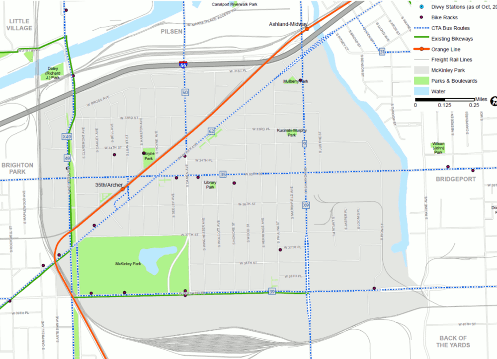
Source: Chicago Metropolitan Agency for Planning, 2018.
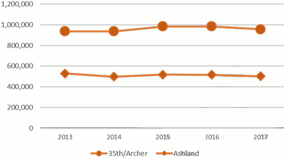
The 35th/Archer Station experienced an all-time high in annual ridership in 2016 (984,456 boardings), but declined by three percent in 2017, see Figure 2.11. Between 2013 and 2017, the 35th /Archer station increased in annual ridership (2.1 percent) while the CTA Orange Line total ridership decreased over the same period (-1.2 percent). The higher density of people and destinations near the 35th /Archer Station is likely why there are more CTA riders compared to the Ashland Station.
Both stations are above ground and equipped with an elevator for wheelchair access. The 35th/Archer Station also offers a Park and Ride Lot.
Figure 2.11 Annual CTA Ridership
Source: Chicago Transit Authority
CTA Bus System
Six CTA bus routes directly serve the McKinley Park study area. Of the study area routes, No. 9 Ashland has the greatest weekday ridership (17,165), followed by the No. 49 Western (17,135), and No. 62 Archer (10,771). No. 9 Ashland and No. 49 Western run North-South and offer Express Routes making limited stops weekdays during rush hours. No. 62 Archer is especially important to McKinley Park, given that it runs between downtown and Midway airport. All three routes operate with “Night Owl” service, with 30-minute headways between midnight and 5:00 a.m.
Route No. 50 Damen runs North-South from Edgewater and Clark to 35th /Archer. Routes No. 35 31st /35th and No. 39 Pershing run East-West through the study area. All routes except No. 9 and No. 49 intersect at the 35th /Archer Bus Terminal, offering connections to the CTA Orange Line 35th/Archer Station.
Automobile Traffic and Road Jurisdiction
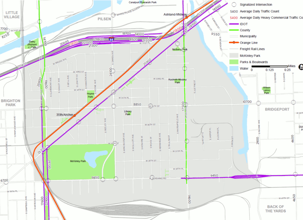
Roads provide space for three vital functions within a community – mobility, commerce and civic life. The functional classification of a road describes the character of the road in terms of vehicular mobility and the level of service they are intended to provide. With several streets or street segments outside of the City of Chicago’s jurisdiction, the ability to make improvements, control access, or unify the streetscape requires coordination between the Cook County Department of Transportation and Highways (the County), the Chicago Department of Transportation (CDOT), and the Illinois Department of Transportation (IDOT).
Interstate
The Stevenson Expressway (I-55) defines the north boundary of the study area. Expressways are designed for high-speed, long-distance or interstate travel and have high traffic volume, including heavy freight truck traffic. While the expressway makes McKinley Park very accessible for automobile and truck traffic, it also creates challenging conditions for pedestrians and cyclists, limiting their accessibility. Access to the interstate in both directions is available via the I-55 interchange at Ashland Avenue and at Damen Avenue.
Principal Arterials
McKinley Park has two principal arterials: Western Avenue and Pershing Road. Principal arterials are designated for higher speed travel than minor arterials and local roads and to accommodate longer distance trips. Segments of Western Avenue (south from 34 th Street) and Pershing Road (east of Ashland Avenue) and are under the Jurisdiction of IDOT (see Figure 2.12). The segment of Western Avenue north of 34th Street is under the Jurisdiction of the County. CDOT maintains Pershing Road east of Ashland Avenue. Western Avenue has nearly double the traffic volume as Pershing Road. While the volume of traffic along Pershing Road is low compared to other roads in the study area, there is an uptick in traffic volume between Western Avenue and Ashland Avenue.
Minor Arterials
McKinley Park only has one minor arterial: Ashland Avenue. This north-south arterial carries less traffic than principal arterial Western Avenue and collector Damen Avenue, but sees a noticeable uptick in traffic volume near the I-55 Interchange. The majority of Ashland Avenue in the study area is under the jurisdiction of the County, except north of Archer Avenue, which falls under IDOT’s jurisdiction.
Collectors
McKinley Park has four major collector roads, which distribute traffic from local streets to the arterials: 35th Street, Archer Avenue, Damen Avenue, and Western Boulevard. Of all the roadways in the study area, Archer Avenue carries the highest volume of traffic followed by collector Damen Avenue. Traffic volumes along Archer Avenue pick up significantly and remain steady from end-to-end of the study area. Many stakeholders identified Archer Avenue as “fast-moving auto-oriented thoroughfare.” IDOT maintains jurisdiction over Archer Avenue and the segment of Western Boulevard south of Archer Avenue. Any efforts to make improvements, control access, or unify the existing streetscape with other streets will require cooperation and coordination with IDOT.
East-west collector 35 th street carries the lowest volumes of traffic in the study, with significantly higher volumes east of Ashland Avenue. This may be due to industrial occupants located east of Ashland Avenue along 35 th Street.
Local Roads
The remaining roads in the study area are local streets and provide access to private property with limited through traffic. The travel speeds and traffic volumes are low and mostly consist of one automobile lane and a parking lane on each side of the road. All local roads in McKinley Park fall under the jurisdiction of CDOT.
Figure 2.12 McKinley Park Roadway Jurisdiction and Average Daily Traffic Count
Source: Chicago Metropolitan Agency for Planning, 2018.
Freight
The Chicago region is the freight hub of the United States and McKinley Park is at the center of it. McKinley Park’s close proximity to I-55, I-90, and five freight rail lines (Atchison Topika and Santa Fe Railroad, Burlington Northern Santa Fe, Central Illinois Railroad, CSX Transportation, and the Northfolk Southern Railroad) offer logistics advantages for businesses. Businesses in the neighborhood’s industrial areas (26.6 percent of the land use), specifically the industrial areas south of Pershing Road, are especially well served, as businesses can load and unload directly from the railroad tracks. The I-55 interchange at Ashland Ave and at Damen Avenue, which are a designated Class II truck route, are useful for freight as they offer access to the interstate in both directions and have long ramps and wide turning radii.
Waterways
The South Branch of the Chicago River provides the community with easy access to the international maritime freight network. Running along the eastern border of the study area, the South Branch provides access to Lake Michigan to the north and connects to the Chicago Sanitary and Ship Canal, eventually leading to the Mississippi River and Gulf of Mexico to the south.










Log In to comment on this item.
Subscribe
Report
My comments