


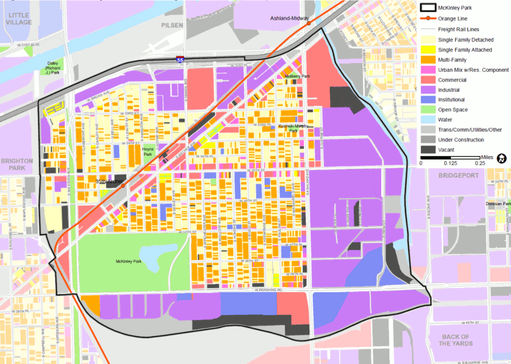
Livable communities depend on a mix of land uses that provide the homes, jobs and businesses, civic institutions, and open space that are essential for daily living. An assessment of the existing land use pattern in McKinley Park provides a foundational understanding of what is in the community now and how that could change in the future (Figure 2.3 and Table 2.1).
The largest portion of the land area in McKinley Park is devoted to residential dwellings (28.2 percent), nearly evenly split between single-family homes (14.7 percent) and multi-family uses (13.5 percent). Single-family and multi-family housing intermixes throughout the community with most multi-family development consisting of two story buildings. Mixed-used properties containing residential units, typically on the second floor, constitute 1.3 percent of the land use and are generally located along 35th Street and Archer Avenue, and in the southeastern portion of the community.
The second largest portion (26.6 percent) of the total land area in the study area is dedicated to industrial uses. These land uses include the historic CMD and two Planned Manufacturing Districts (PMDs), which are found along the south and east borders of McKinley Park, near major railroads and the South Branch of the Chicago River. Significant industrial uses are also located on the north border of the community near I-55.
Table 2.1 McKinley Park Study Area Existing Land Use, 2013
| Land Use | Acres | Percent |
| Single-Family Residential | 120.14 | 14.7% |
| Multi-Family Residential | 110.53 | 13.5% |
| Commercial | 71.79 | 8.8% |
| Mixed Use | 11.82 | 1.4% |
| Industrial | 217.43 | 26.6% |
| Institutional | 50.47 | 6.2% |
| Transportation/Communications/Utility | 94.73 | 11.6% |
| Open Space | 75.08 | 9.2% |
| Water | 10.3 | 1.3% |
| Vacant | 53.81 | 6.6% |
| Total | 816.1 | 100% |
Source: CMAP 2013 Land Use Inventory
*Includes updates based on May 2018 field reconnaissance.
Commercial development in McKinley Park is concentrated along major corridors —Archer Avenue, 35th Street, and Ashland Avenue. As the most prominent arterial in the study area, Archer Avenue provides the majority of this commercial land, with nearly 53 acres of commercial property directly adjacent to it.
Institutional uses are generally distributed throughout the community and include large city-owned properties located in the CMD and the southeastern portion of the study area. Existing transportation, communications, and utility uses make up 11.6 percent of the land and include transit stations and rail lines, as well as public streets and sidewalks. Open space makes up nine percent of McKinley Park’s total land area. The majority of the open space is located within the 69-acre McKinley Park and the Western boulevard system, which are maintained by the Chicago Park District. More information about Parks and Open Space is available in Section 9 of this report.
Figure 2.3 McKinley Park Existing Land Use (2013)
Source: Chicago Metropolitan Agency for Planning, 2018.
Zoning and other development regulations play an important role in determining the form and character of existing and future development. Updating development regulations to be consistent with a community’s land use vision is often a critical step to implementing a neighborhood plan.










Log In to comment on this item.
Subscribe
Report
My comments