


A modern transportation system is indispensable; residents must be able to travel efficiently, easily, and safely around McKinley Park as well as the larger Chicago region to sustain our economy and quality of life. Businesses must be able to count on the timely delivery of their goods. With an aging and congested transportation system and limited funding, strategic maintenance and modernization are necessary to respond to mobility needs and trends.
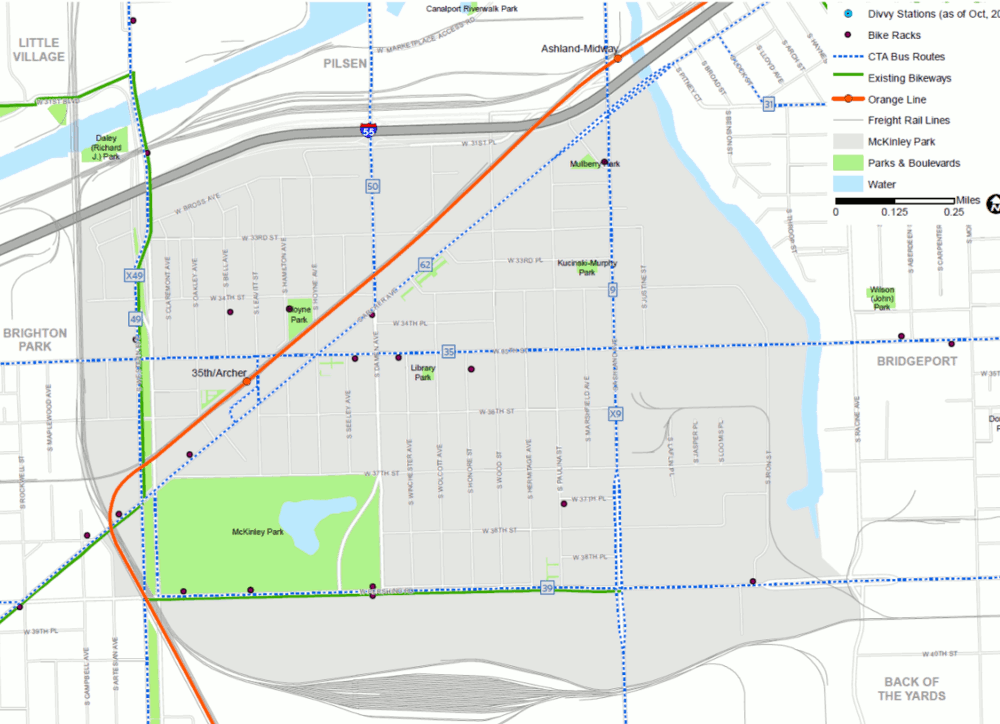
McKinley Park’s location provides excellent access to the regional transportation network with close proximity to the Stevenson Expressway (I-55), Kennedy Expressway (I-90), freight rail (Atchison Topika and Santa Fe Railroad, Burlington Northern Santa Fe, Central Illinois Railroad, CSX Transportation, and the Northfolk Southern Railroad), the CTA Orange Line, and six CTA bus routes. There are several on-street bicycle facilities, including bike racks, six Divvy stations, and designated bikeways along Pershing Road and Western Avenue (Figure 2.8).
Commuting in McKinley Park
Traveling to and from work is often the largest component of an individual’s travel behavior. Only 3.1 percent of 5,670 employed McKinley Park residents both live and work in the study area; the remaining 96.9 percent work outside the neighborhood. Nevertheless, the great majority of McKinley Park’s labor force works close by – 72.4 percent of employed residents work within 10 miles from the study area, and 19 percent work 10 to 24 miles away.
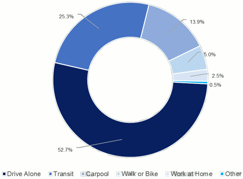
Fifty-three percent of McKinley Park residents drive to work alone, and 25 percent take transit for their daily commute, 14 percent carpool, five percent use active transportation, and almost three percent work from home (Figure 2.9).
Figure 2.9 Commute Mode Share for McKinley Park Residents
Source: CMAP analysis of American Community Survey five year estimates for 2012-2016.
Conditions for Pedestrians and Cyclists
Walkability was cited by many as one of the most important factors in the health and vitality of the community. Sidewalks are prevalent on both sides of streets throughout residential and commercial areas of McKinley Park. However, high traffic levels, vacant parcels, and a lack of street trees along main commercial corridors can make walking unsafe and uninviting. McKinley Park’s core areas have complete crosswalks at most intersections, including signalized crosswalks at major intersections. While most sidewalks throughout the community are walkable and well maintained, Archer Avenue and Ashland Avenue can be difficult to cross due to its wide right-of-way and fast-moving traffic. The segment of the study area east of Ashland Avenue was an area of concern to residents given the lack of sidewalks and access to the river.
Additionally, many viaducts that run below the rail tracks adjacent to Archer Avenue are in various states of disrepair, often creating an uninviting environment for both pedestrians and cyclists. These viaducts are owned and maintained by private rail companies and not the city or federal government. This presents additional challenges to improve the conditions of these viaducts, as many improvements would need to be done in coordination with those private parties.
Many people ride bikes for transportation and recreation in McKinley Park. The 12th Ward Alderman’s office coordinates an annual family bike event that brings together many local cyclists and visitors. The McKinley Park Kidical Mass is also a very active group in the community. Designated bike routes can be found along Pershing Road between Western Avenue and Ashland Avenue; and south of Archer Avenue from Western Avenue and north of Western Avenue from Archer Avenue. Some community members noted that cycling on Archer Avenue can be difficult due to its higher traffic speeds. But biking conditions along Archer Avenue may change soon, as new bicycle infrastructure is slated for McKinley Park. CDOT’s Streets for Cycling Plan 2020 designates Archer Avenue as a “Spoke Route,” one of Chicago’s most direct routes in and out of the downtown area for bicyclists, intended to “reimagine over the next eight years to provide bicyclists with the safest, quickest and most comfortable accommodations possible.”
Transit
Overall, McKinley Park is well-served by public transit compared to similar city neighborhoods and other regional communities, and its residents appear to take advantage. CTA provides bus and rail service to the study area. The closest Metra commuter rail station (Western Avenue on the BNSF) is two and a half miles from the study area boundary. While “Drive Alone” is the most common commute mode among residents (52.7 percent), public transit is second at 25.3 percent.
CTA Rail System
The CTA Orange Line provides service between Midway Airport and downtown (Loop) and runs through the study area with stops at Ashland and 35th /Archer. While the Ashland Station is located just outside the study area, it serves as a key access point to residents living in the northeast portion of the community. The Ashland Station provides connections to CTA bus routes No. 9 Ashland and No. 9X Ashland Express; and the 35th/Archer Station serves as a transit hub offering connections to CTA bus routes No. 35 31st /35th , No. 39 Pershing, No. 50 Damen, and No. 62 Archer, see Figure 2.10.
Figure 2.10 McKinley Park Transportation Map
Source: Chicago Metropolitan Agency for Planning, 2018.
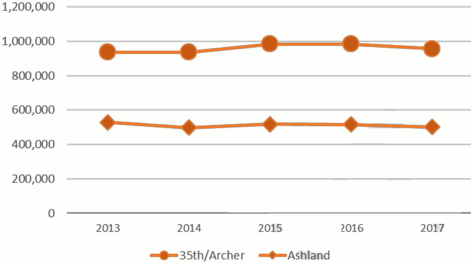
The 35th/Archer Station experienced an all-time high in annual ridership in 2016 (984,456 boardings), but declined by three percent in 2017, see Figure 2.11. Between 2013 and 2017, the 35th /Archer station increased in annual ridership (2.1 percent) while the CTA Orange Line total ridership decreased over the same period (-1.2 percent). The higher density of people and destinations near the 35th /Archer Station is likely why there are more CTA riders compared to the Ashland Station.
Both stations are above ground and equipped with an elevator for wheelchair access. The 35th/Archer Station also offers a Park and Ride Lot.
Figure 2.11 Annual CTA Ridership
Source: Chicago Transit Authority
CTA Bus System
Six CTA bus routes directly serve the McKinley Park study area. Of the study area routes, No. 9 Ashland has the greatest weekday ridership (17,165), followed by the No. 49 Western (17,135), and No. 62 Archer (10,771). No. 9 Ashland and No. 49 Western run North-South and offer Express Routes making limited stops weekdays during rush hours. No. 62 Archer is especially important to McKinley Park, given that it runs between downtown and Midway airport. All three routes operate with “Night Owl” service, with 30-minute headways between midnight and 5:00 a.m.
Route No. 50 Damen runs North-South from Edgewater and Clark to 35th /Archer. Routes No. 35 31st /35th and No. 39 Pershing run East-West through the study area. All routes except No. 9 and No. 49 intersect at the 35th /Archer Bus Terminal, offering connections to the CTA Orange Line 35th/Archer Station.
Automobile Traffic and Road Jurisdiction
Roads provide space for three vital functions within a community – mobility, commerce and civic life. The functional classification of a road describes the character of the road in terms of vehicular mobility and the level of service they are intended to provide. With several streets or street segments outside of the City of Chicago’s jurisdiction, the ability to make improvements, control access, or unify the streetscape requires coordination between the Cook County Department of Transportation and Highways (the County), the Chicago Department of Transportation (CDOT), and the Illinois Department of Transportation (IDOT).
Interstate
The Stevenson Expressway (I-55) defines the north boundary of the study area. Expressways are designed for high-speed, long-distance or interstate travel and have high traffic volume, including heavy freight truck traffic. While the expressway makes McKinley Park very accessible for automobile and truck traffic, it also creates challenging conditions for pedestrians and cyclists, limiting their accessibility. Access to the interstate in both directions is available via the I-55 interchange at Ashland Avenue and at Damen Avenue.
Principal Arterials
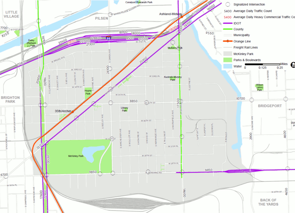
McKinley Park has two principal arterials: Western Avenue and Pershing Road. Principal arterials are designated for higher speed travel than minor arterials and local roads and to accommodate longer distance trips. Segments of Western Avenue (south from 34 th Street) and Pershing Road (east of Ashland Avenue) and are under the Jurisdiction of IDOT (see Figure 2.12). The segment of Western Avenue north of 34th Street is under the Jurisdiction of the County. CDOT maintains Pershing Road east of Ashland Avenue. Western Avenue has nearly double the traffic volume as Pershing Road. While the volume of traffic along Pershing Road is low compared to other roads in the study area, there is an uptick in traffic volume between Western Avenue and Ashland Avenue.
Minor Arterials
McKinley Park only has one minor arterial: Ashland Avenue. This north-south arterial carries less traffic than principal arterial Western Avenue and collector Damen Avenue, but sees a noticeable uptick in traffic volume near the I-55 Interchange. The majority of Ashland Avenue in the study area is under the jurisdiction of the County, except north of Archer Avenue, which falls under IDOT’s jurisdiction.
Collectors
McKinley Park has four major collector roads, which distribute traffic from local streets to the arterials: 35th Street, Archer Avenue, Damen Avenue, and Western Boulevard. Of all the roadways in the study area, Archer Avenue carries the highest volume of traffic followed by collector Damen Avenue. Traffic volumes along Archer Avenue pick up significantly and remain steady from end-to-end of the study area. Many stakeholders identified Archer Avenue as “fast-moving auto-oriented thoroughfare.” IDOT maintains jurisdiction over Archer Avenue and the segment of Western Boulevard south of Archer Avenue. Any efforts to make improvements, control access, or unify the existing streetscape with other streets will require cooperation and coordination with IDOT.
East-west collector 35 th street carries the lowest volumes of traffic in the study, with significantly higher volumes east of Ashland Avenue. This may be due to industrial occupants located east of Ashland Avenue along 35 th Street.
Local Roads
The remaining roads in the study area are local streets and provide access to private property with limited through traffic. The travel speeds and traffic volumes are low and mostly consist of one automobile lane and a parking lane on each side of the road. All local roads in McKinley Park fall under the jurisdiction of CDOT.
Figure 2.12 McKinley Park Roadway Jurisdiction and Average Daily Traffic Count
Source: Chicago Metropolitan Agency for Planning, 2018.
Freight
The Chicago region is the freight hub of the United States and McKinley Park is at the center of it. McKinley Park’s close proximity to I-55, I-90, and five freight rail lines (Atchison Topika and Santa Fe Railroad, Burlington Northern Santa Fe, Central Illinois Railroad, CSX Transportation, and the Northfolk Southern Railroad) offer logistics advantages for businesses. Businesses in the neighborhood’s industrial areas (26.6 percent of the land use), specifically the industrial areas south of Pershing Road, are especially well served, as businesses can load and unload directly from the railroad tracks. The I-55 interchange at Ashland Ave and at Damen Avenue, which are a designated Class II truck route, are useful for freight as they offer access to the interstate in both directions and have long ramps and wide turning radii.
Waterways
The South Branch of the Chicago River provides the community with easy access to the international maritime freight network. Running along the eastern border of the study area, the South Branch provides access to Lake Michigan to the north and connects to the Chicago Sanitary and Ship Canal, eventually leading to the Mississippi River and Gulf of Mexico to the south.










Log In to comment on this item.
Subscribe
Report
My comments